You are here: Home > Network List > US - United States National Seismic Network Stations List
> Station WUAZ Wupatki, Arizona, USA > Earthquake Result Viewer
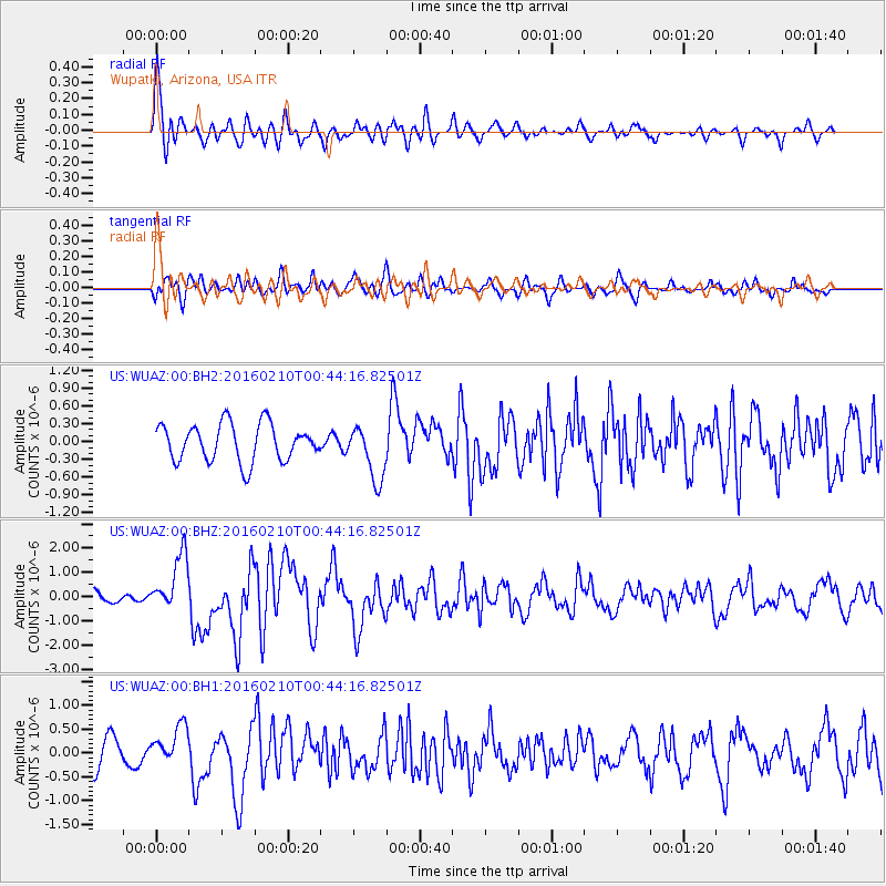
WUAZ Wupatki, Arizona, USA - Earthquake Result Viewer
*The percent match for this event was below the threshold and hence no stack was calculated.
| Earthquake location: |
Near Coast Of Central Chile |
| Earthquake latitude/longitude: |
-30.6/-71.6 |
| Earthquake time(UTC): |
2016/02/10 (041) 00:33:05 GMT |
| Earthquake Depth: |
32 km |
| Earthquake Magnitude: |
6.3 MWB |
| Earthquake Catalog/Contributor: |
NEIC PDE/NEIC COMCAT |
|
| Network: |
US United States National Seismic Network |
| Station: |
WUAZ Wupatki, Arizona, USA |
| Lat/Lon: |
35.52 N/111.37 W |
| Elevation: |
1592 m |
|
| Distance: |
75.7 deg |
| Az: |
327.424 deg |
| Baz: |
145.328 deg |
| Ray Param: |
$rayparam |
*The percent match for this event was below the threshold and hence was not used in the summary stack. |
|
| Radial Match: |
73.02714 % |
| Radial Bump: |
400 |
| Transverse Match: |
64.96992 % |
| Transverse Bump: |
400 |
| SOD ConfigId: |
1427151 |
| Insert Time: |
2016-02-24 01:02:25.767 +0000 |
| GWidth: |
2.5 |
| Max Bumps: |
400 |
| Tol: |
0.001 |
|
Signal To Noise
| Channel | StoN | STA | LTA |
| US:WUAZ:00:BHZ:20160210T00:44:16.82501Z | 3.6161954 | 1.1642334E-6 | 3.2194978E-7 |
| US:WUAZ:00:BH1:20160210T00:44:16.82501Z | 1.2089041 | 4.0262938E-7 | 3.3305318E-7 |
| US:WUAZ:00:BH2:20160210T00:44:16.82501Z | 1.4798037 | 4.6343618E-7 | 3.1317413E-7 |
| Arrivals |
| Ps | |
| PpPs | |
| PsPs/PpSs | |


