You are here: Home > Network List > AV - Alaska Volcano Observatory Stations List
> Station SPCR Ckakachatna River, Mount Spurr, Alaska > Earthquake Result Viewer
SPCR Ckakachatna River, Mount Spurr, Alaska - Earthquake Result Viewer
*The percent match for this event was below the threshold and hence no stack was calculated.
| Earthquake location: |
Hokkaido, Japan Region |
| Earthquake latitude/longitude: |
41.8/142.9 |
| Earthquake time(UTC): |
2017/09/10 (253) 08:44:24 GMT |
| Earthquake Depth: |
45 km |
| Earthquake Magnitude: |
5.5 Mww |
| Earthquake Catalog/Contributor: |
NEIC PDE/us |
|
| Network: |
AV Alaska Volcano Observatory |
| Station: |
SPCR Ckakachatna River, Mount Spurr, Alaska |
| Lat/Lon: |
61.20 N/152.21 W |
| Elevation: |
984 m |
|
| Distance: |
42.7 deg |
| Az: |
40.248 deg |
| Baz: |
273.702 deg |
| Ray Param: |
$rayparam |
*The percent match for this event was below the threshold and hence was not used in the summary stack. |
|
| Radial Match: |
72.21048 % |
| Radial Bump: |
400 |
| Transverse Match: |
56.5051 % |
| Transverse Bump: |
400 |
| SOD ConfigId: |
13570011 |
| Insert Time: |
2019-04-28 18:10:47.321 +0000 |
| GWidth: |
2.5 |
| Max Bumps: |
400 |
| Tol: |
0.001 |
|
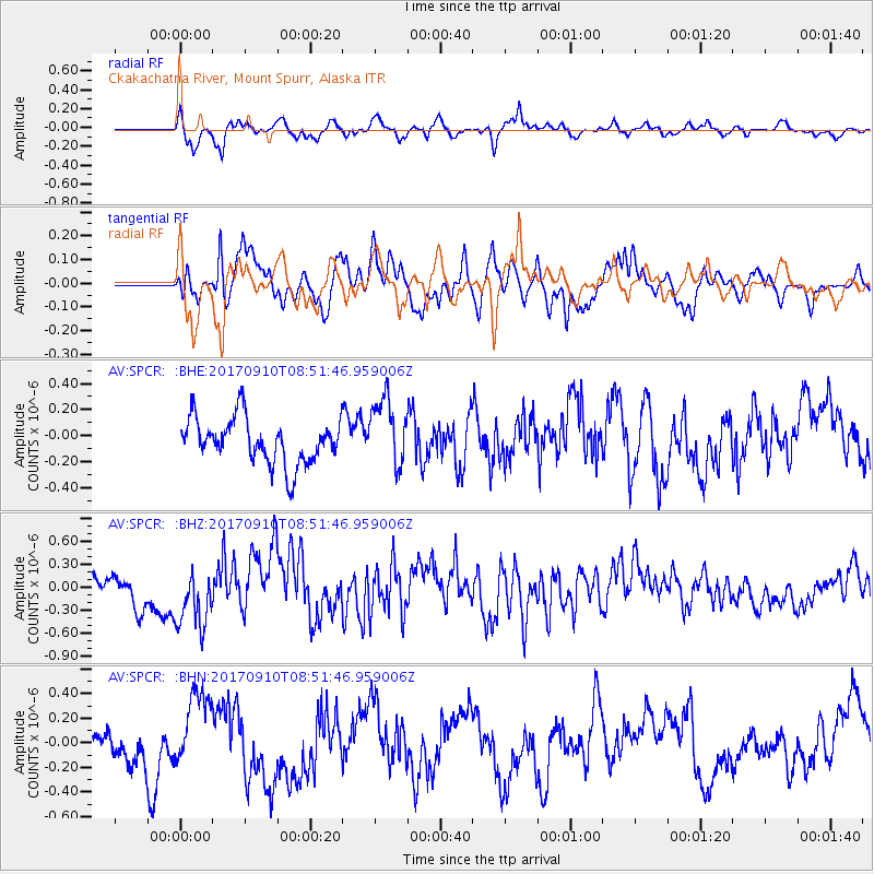
Signal To Noise
| Channel | StoN | STA | LTA |
| AV:SPCR: :BHZ:20170910T08:51:46.959006Z | 1.7033873 | 3.9814452E-7 | 2.3373694E-7 |
| AV:SPCR: :BHN:20170910T08:51:46.959006Z | 2.1972003 | 3.0789417E-7 | 1.4013023E-7 |
| AV:SPCR: :BHE:20170910T08:51:46.959006Z | 1.5342911 | 2.6522295E-7 | 1.728635E-7 |
| Arrivals |
| Ps | |
| PpPs | |
| PsPs/PpSs | |


