You are here: Home > Network List > CI - Caltech Regional Seismic Network Stations List
> Station CHF Chilao Flat Rngr Sta, Altadena, CA, USA > Earthquake Result Viewer
CHF Chilao Flat Rngr Sta, Altadena, CA, USA - Earthquake Result Viewer
| Earthquake location: |
East Of Kuril Islands |
| Earthquake latitude/longitude: |
47.1/155.5 |
| Earthquake time(UTC): |
2007/01/13 (013) 19:37:32 GMT |
| Earthquake Depth: |
10 km |
| Earthquake Magnitude: |
5.6 MB, 4.7 MS |
| Earthquake Catalog/Contributor: |
WHDF/NEIC |
|
| Network: |
CI Caltech Regional Seismic Network |
| Station: |
CHF Chilao Flat Rngr Sta, Altadena, CA, USA |
| Lat/Lon: |
34.33 N/118.03 W |
| Elevation: |
1594 m |
|
| Distance: |
63.6 deg |
| Az: |
67.243 deg |
| Baz: |
310.363 deg |
| Ray Param: |
0.059476636 |
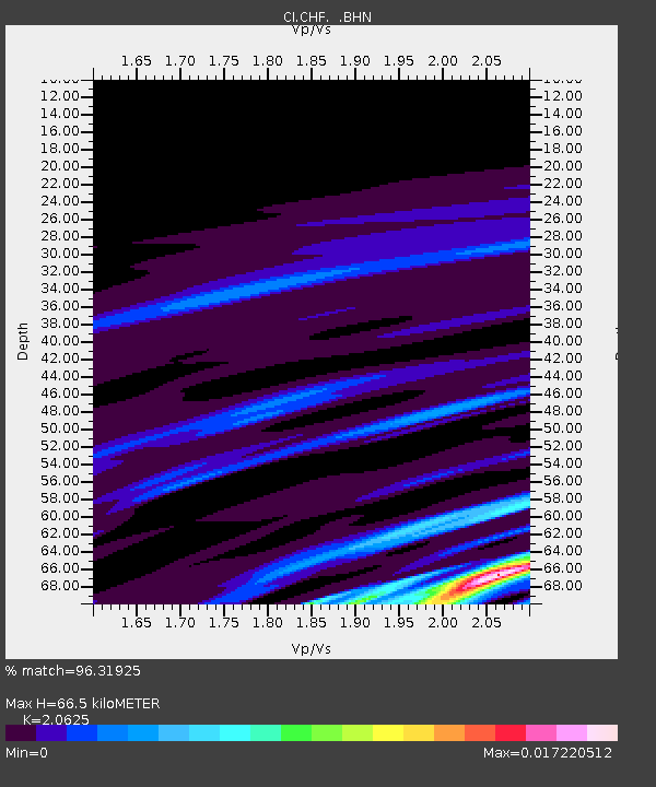
| Estimated Moho Depth: |
66.5 km |
| Estimated Crust Vp/Vs: |
2.06 |
| Assumed Crust Vp: |
6.1 km/s |
| Estimated Crust Vs: |
2.958 km/s |
| Estimated Crust Poisson's Ratio: |
0.35 |
|
| Radial Match: |
96.31925 % |
| Radial Bump: |
105 |
| Transverse Match: |
99.78504 % |
| Transverse Bump: |
21 |
| SOD ConfigId: |
2564 |
| Insert Time: |
2010-02-26 01:26:18.951 +0000 |
| GWidth: |
2.5 |
| Max Bumps: |
400 |
| Tol: |
0.001 |
|
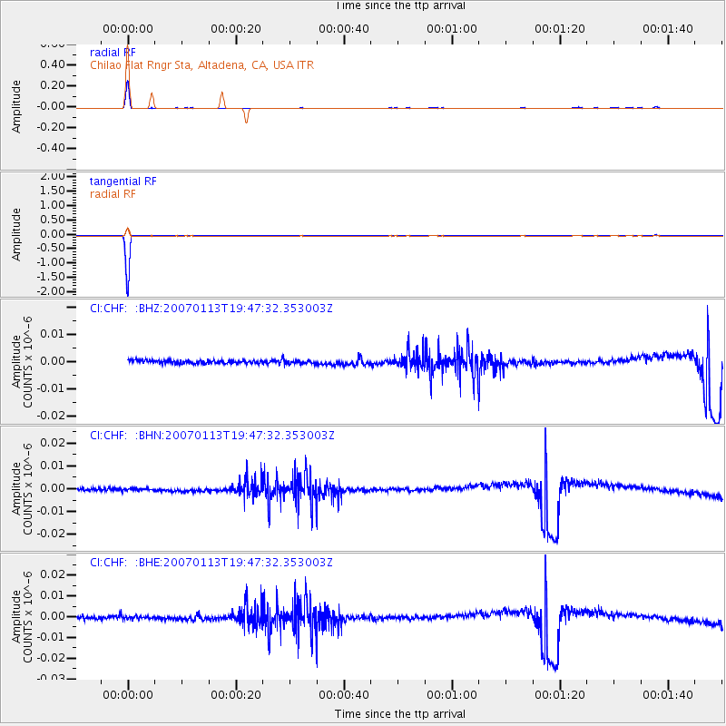
Signal To Noise
| Channel | StoN | STA | LTA |
| CI:CHF: :BHN:20070113T19:47:32.353003Z | 0.9342748 | 4.6296714E-10 | 4.9553633E-10 |
| CI:CHF: :BHE:20070113T19:47:32.353003Z | 0.9681334 | 6.627116E-10 | 6.845251E-10 |
| CI:CHF: :BHZ:20070113T19:47:32.353003Z | 1.0109245 | 5.6653915E-10 | 5.604169E-10 |
| Arrivals |
| Ps | 12 SECOND |
| PpPs | 32 SECOND |
| PsPs/PpSs | 44 SECOND |


