You are here: Home > Network List > TA - USArray Transportable Network (new EarthScope stations) Stations List
> Station H22A Lovato Ranch, Clearmont, WY, USA > Earthquake Result Viewer
H22A Lovato Ranch, Clearmont, WY, USA - Earthquake Result Viewer
| Earthquake location: |
Kuril Islands |
| Earthquake latitude/longitude: |
50.8/155.0 |
| Earthquake time(UTC): |
2009/04/21 (111) 05:26:11 GMT |
| Earthquake Depth: |
152 km |
| Earthquake Magnitude: |
6.0 MB, 6.2 MW, 6.2 MW |
| Earthquake Catalog/Contributor: |
WHDF/NEIC |
|
| Network: |
TA USArray Transportable Network (new EarthScope stations) |
| Station: |
H22A Lovato Ranch, Clearmont, WY, USA |
| Lat/Lon: |
44.59 N/106.35 W |
| Elevation: |
1276 m |
|
| Distance: |
61.8 deg |
| Az: |
53.291 deg |
| Baz: |
314.639 deg |
| Ray Param: |
0.06020568 |
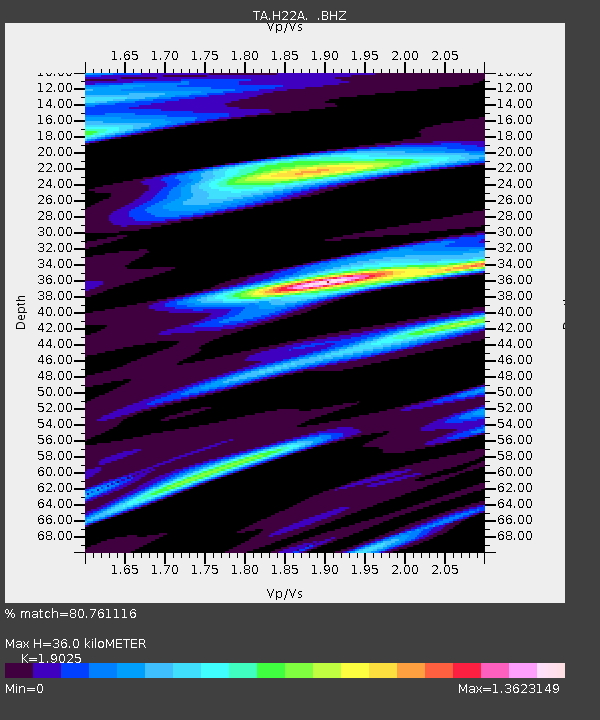
| Estimated Moho Depth: |
36.0 km |
| Estimated Crust Vp/Vs: |
1.90 |
| Assumed Crust Vp: |
6.178 km/s |
| Estimated Crust Vs: |
3.247 km/s |
| Estimated Crust Poisson's Ratio: |
0.31 |
|
| Radial Match: |
80.761116 % |
| Radial Bump: |
400 |
| Transverse Match: |
69.86414 % |
| Transverse Bump: |
400 |
| SOD ConfigId: |
2760 |
| Insert Time: |
2010-03-06 03:34:01.454 +0000 |
| GWidth: |
2.5 |
| Max Bumps: |
400 |
| Tol: |
0.001 |
|

Signal To Noise
| Channel | StoN | STA | LTA |
| TA:H22A: :BHZ:20090421T05:35:43.275005Z | 7.0967484 | 1.2815007E-6 | 1.8057574E-7 |
| TA:H22A: :BHN:20090421T05:35:43.275005Z | 3.0059607 | 4.942359E-7 | 1.6441862E-7 |
| TA:H22A: :BHE:20090421T05:35:43.275005Z | 2.2162228 | 5.2613865E-7 | 2.374033E-7 |
| Arrivals |
| Ps | 5.5 SECOND |
| PpPs | 16 SECOND |
| PsPs/PpSs | 22 SECOND |


