You are here: Home > Network List > TA - USArray Transportable Network (new EarthScope stations) Stations List
> Station H22A Lovato Ranch, Clearmont, WY, USA > Earthquake Result Viewer
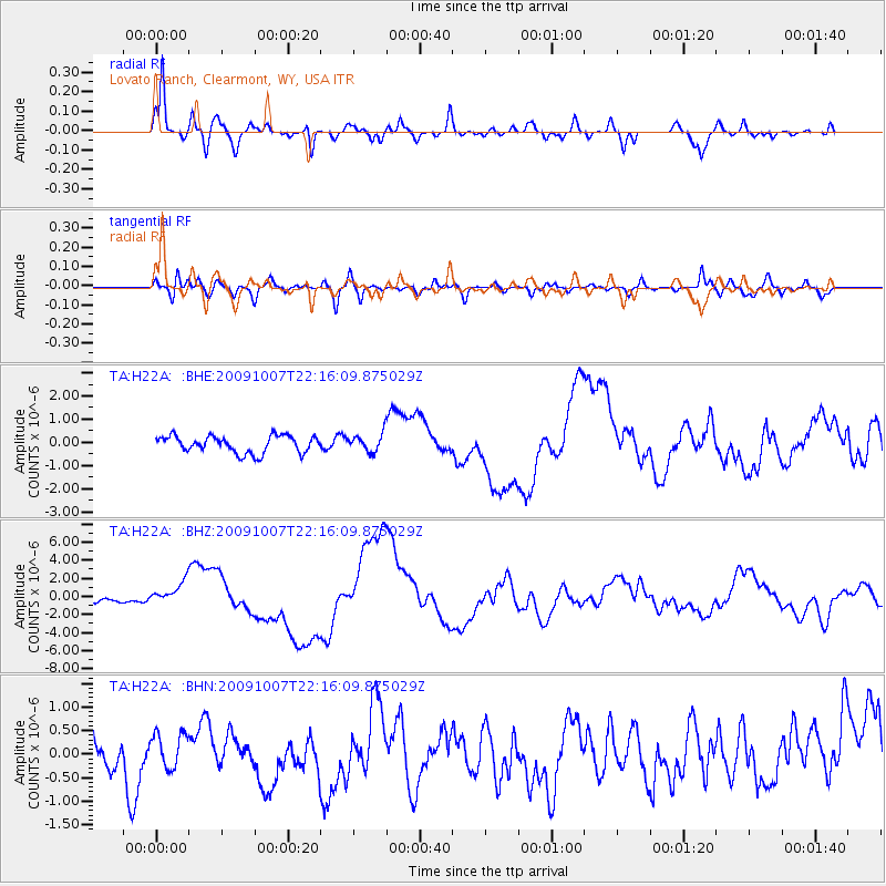
H22A Lovato Ranch, Clearmont, WY, USA - Earthquake Result Viewer
| Earthquake location: |
Vanuatu Islands |
| Earthquake latitude/longitude: |
-13.0/166.5 |
| Earthquake time(UTC): |
2009/10/07 (280) 22:03:14 GMT |
| Earthquake Depth: |
45 km |
| Earthquake Magnitude: |
6.4 MB, 7.3 MS, 7.6 MW, 7.7 MW |
| Earthquake Catalog/Contributor: |
WHDF/NEIC |
|
| Network: |
TA USArray Transportable Network (new EarthScope stations) |
| Station: |
H22A Lovato Ranch, Clearmont, WY, USA |
| Lat/Lon: |
44.59 N/106.35 W |
| Elevation: |
1276 m |
|
| Distance: |
97.0 deg |
| Az: |
45.964 deg |
| Baz: |
258.739 deg |
| Ray Param: |
0.04032225 |
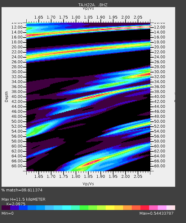
| Estimated Moho Depth: |
11.5 km |
| Estimated Crust Vp/Vs: |
2.10 |
| Assumed Crust Vp: |
6.178 km/s |
| Estimated Crust Vs: |
2.946 km/s |
| Estimated Crust Poisson's Ratio: |
0.35 |
|
| Radial Match: |
89.611374 % |
| Radial Bump: |
400 |
| Transverse Match: |
61.2522 % |
| Transverse Bump: |
400 |
| SOD ConfigId: |
2622 |
| Insert Time: |
2010-03-06 03:34:13.434 +0000 |
| GWidth: |
2.5 |
| Max Bumps: |
400 |
| Tol: |
0.001 |
|
Signal To Noise
| Channel | StoN | STA | LTA |
| TA:H22A: :BHZ:20091007T22:16:09.875029Z | 4.09542 | 1.2798774E-6 | 3.1251437E-7 |
| TA:H22A: :BHN:20091007T22:16:09.875029Z | 1.0185316 | 3.7053812E-7 | 3.637964E-7 |
| TA:H22A: :BHE:20091007T22:16:09.875029Z | 1.0712929 | 3.8918722E-7 | 3.632874E-7 |
| Arrivals |
| Ps | 2.1 SECOND |
| PpPs | 5.7 SECOND |
| PsPs/PpSs | 7.8 SECOND |


