You are here: Home > Network List > TA - USArray Transportable Network (new EarthScope stations) Stations List
> Station G31M Satah River, YT, CAN > Earthquake Result Viewer
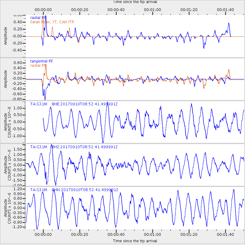
G31M Satah River, YT, CAN - Earthquake Result Viewer
*The percent match for this event was below the threshold and hence no stack was calculated.
| Earthquake location: |
Hokkaido, Japan Region |
| Earthquake latitude/longitude: |
41.8/142.9 |
| Earthquake time(UTC): |
2017/09/10 (253) 08:44:24 GMT |
| Earthquake Depth: |
45 km |
| Earthquake Magnitude: |
5.5 Mww |
| Earthquake Catalog/Contributor: |
NEIC PDE/us |
|
| Network: |
TA USArray Transportable Network (new EarthScope stations) |
| Station: |
G31M Satah River, YT, CAN |
| Lat/Lon: |
66.92 N/134.27 W |
| Elevation: |
61 m |
|
| Distance: |
49.7 deg |
| Az: |
30.854 deg |
| Baz: |
283.339 deg |
| Ray Param: |
$rayparam |
*The percent match for this event was below the threshold and hence was not used in the summary stack. |
|
| Radial Match: |
66.13859 % |
| Radial Bump: |
400 |
| Transverse Match: |
68.478836 % |
| Transverse Bump: |
400 |
| SOD ConfigId: |
13570011 |
| Insert Time: |
2019-04-28 18:16:24.166 +0000 |
| GWidth: |
2.5 |
| Max Bumps: |
400 |
| Tol: |
0.001 |
|
Signal To Noise
| Channel | StoN | STA | LTA |
| TA:G31M: :BHZ:20170910T08:52:41.499991Z | 4.0334396 | 1.2094772E-6 | 2.9986248E-7 |
| TA:G31M: :BHN:20170910T08:52:41.499991Z | 1.1192231 | 6.743487E-7 | 6.02515E-7 |
| TA:G31M: :BHE:20170910T08:52:41.499991Z | 1.4124733 | 7.832898E-7 | 5.5455195E-7 |
| Arrivals |
| Ps | |
| PpPs | |
| PsPs/PpSs | |


