You are here: Home > Network List > TA - USArray Transportable Network (new EarthScope stations) Stations List
> Station H22A Lovato Ranch, Clearmont, WY, USA > Earthquake Result Viewer
H22A Lovato Ranch, Clearmont, WY, USA - Earthquake Result Viewer
| Earthquake location: |
South Of Tonga Islands |
| Earthquake latitude/longitude: |
-24.1/-175.2 |
| Earthquake time(UTC): |
2009/11/02 (306) 10:47:13 GMT |
| Earthquake Depth: |
9.0 km |
| Earthquake Magnitude: |
6.1 MB, 6.1 MS, 6.2 MW, 6.1 MW |
| Earthquake Catalog/Contributor: |
WHDF/NEIC |
|
| Network: |
TA USArray Transportable Network (new EarthScope stations) |
| Station: |
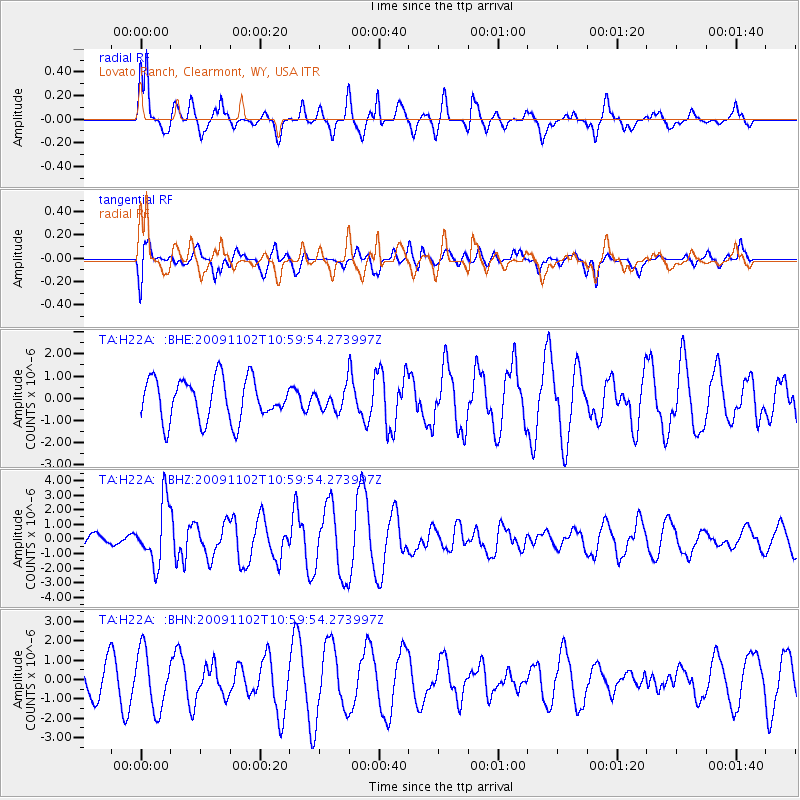
H22A Lovato Ranch, Clearmont, WY, USA |
| Lat/Lon: |
44.59 N/106.35 W |
| Elevation: |
1276 m |
|
| Distance: |
92.8 deg |
| Az: |
41.834 deg |
| Baz: |
238.539 deg |
| Ray Param: |
0.041391347 |
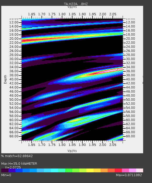
| Estimated Moho Depth: |
35.0 km |
| Estimated Crust Vp/Vs: |
2.07 |
| Assumed Crust Vp: |
6.178 km/s |
| Estimated Crust Vs: |
2.981 km/s |
| Estimated Crust Poisson's Ratio: |
0.35 |
|
| Radial Match: |
82.69642 % |
| Radial Bump: |
400 |
| Transverse Match: |
57.593555 % |
| Transverse Bump: |
400 |
| SOD ConfigId: |
2622 |
| Insert Time: |
2010-03-06 03:34:15.526 +0000 |
| GWidth: |
2.5 |
| Max Bumps: |
400 |
| Tol: |
0.001 |
|
Signal To Noise
| Channel | StoN | STA | LTA |
| TA:H22A: :BHZ:20091102T10:59:54.273997Z | 2.5727384 | 2.0721357E-6 | 8.054203E-7 |
| TA:H22A: :BHN:20091102T10:59:54.273997Z | 2.0432868 | 1.5016727E-6 | 7.349299E-7 |
| TA:H22A: :BHE:20091102T10:59:54.273997Z | 0.52371854 | 4.90969E-7 | 9.374673E-7 |
| Arrivals |
| Ps | 6.2 SECOND |
| PpPs | 17 SECOND |
| PsPs/PpSs | 23 SECOND |


