You are here: Home > Network List > TA - USArray Transportable Network (new EarthScope stations) Stations List
> Station H22A Lovato Ranch, Clearmont, WY, USA > Earthquake Result Viewer
H22A Lovato Ranch, Clearmont, WY, USA - Earthquake Result Viewer
| Earthquake location: |
Kermadec Islands Region |
| Earthquake latitude/longitude: |
-27.4/-176.3 |
| Earthquake time(UTC): |
2009/02/18 (049) 21:53:45 GMT |
| Earthquake Depth: |
25 km |
| Earthquake Magnitude: |
6.8 MB, 7.2 MS, 6.9 MW, 6.9 MW |
| Earthquake Catalog/Contributor: |
WHDF/NEIC |
|
| Network: |
TA USArray Transportable Network (new EarthScope stations) |
| Station: |
H22A Lovato Ranch, Clearmont, WY, USA |
| Lat/Lon: |
44.59 N/106.35 W |
| Elevation: |
1276 m |
|
| Distance: |
95.9 deg |
| Az: |
42.444 deg |
| Baz: |
237.102 deg |
| Ray Param: |
0.040645536 |
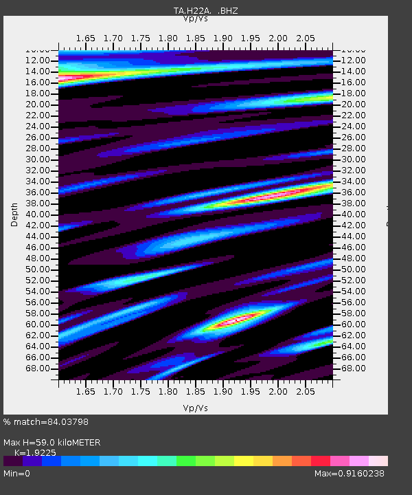
| Estimated Moho Depth: |
59.0 km |
| Estimated Crust Vp/Vs: |
1.92 |
| Assumed Crust Vp: |
6.178 km/s |
| Estimated Crust Vs: |
3.214 km/s |
| Estimated Crust Poisson's Ratio: |
0.31 |
|
| Radial Match: |
84.03798 % |
| Radial Bump: |
400 |
| Transverse Match: |
72.434456 % |
| Transverse Bump: |
400 |
| SOD ConfigId: |
2658 |
| Insert Time: |
2010-03-06 03:34:17.396 +0000 |
| GWidth: |
2.5 |
| Max Bumps: |
400 |
| Tol: |
0.001 |
|
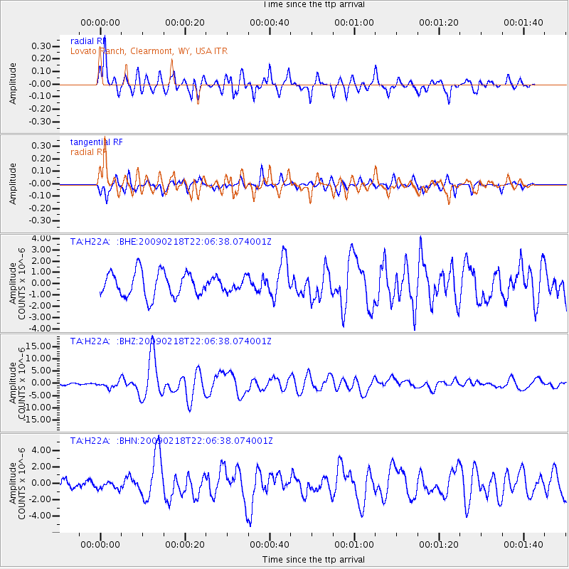
Signal To Noise
| Channel | StoN | STA | LTA |
| TA:H22A: :BHZ:20090218T22:06:38.074001Z | 3.0302072 | 1.3645451E-6 | 4.5031416E-7 |
| TA:H22A: :BHN:20090218T22:06:38.074001Z | 0.7294308 | 4.5722098E-7 | 6.2681886E-7 |
| TA:H22A: :BHE:20090218T22:06:38.074001Z | 0.50667685 | 5.5591426E-7 | 1.0971771E-6 |
| Arrivals |
| Ps | 9.0 SECOND |
| PpPs | 27 SECOND |
| PsPs/PpSs | 36 SECOND |


