You are here: Home > Network List > TA - USArray Transportable Network (new EarthScope stations) Stations List
> Station H22A Lovato Ranch, Clearmont, WY, USA > Earthquake Result Viewer
H22A Lovato Ranch, Clearmont, WY, USA - Earthquake Result Viewer
| Earthquake location: |
Kodiak Island Region, Alaska |
| Earthquake latitude/longitude: |
56.5/-152.7 |
| Earthquake time(UTC): |
2009/03/30 (089) 07:13:07 GMT |
| Earthquake Depth: |
21 km |
| Earthquake Magnitude: |
5.9 MB, 5.9 MS, 5.9 MW, 5.9 MW |
| Earthquake Catalog/Contributor: |
WHDF/NEIC |
|
| Network: |
TA USArray Transportable Network (new EarthScope stations) |
| Station: |
H22A Lovato Ranch, Clearmont, WY, USA |
| Lat/Lon: |
44.59 N/106.35 W |
| Elevation: |
1276 m |
|
| Distance: |
31.2 deg |
| Az: |
92.521 deg |
| Baz: |
309.244 deg |
| Ray Param: |
0.07912205 |
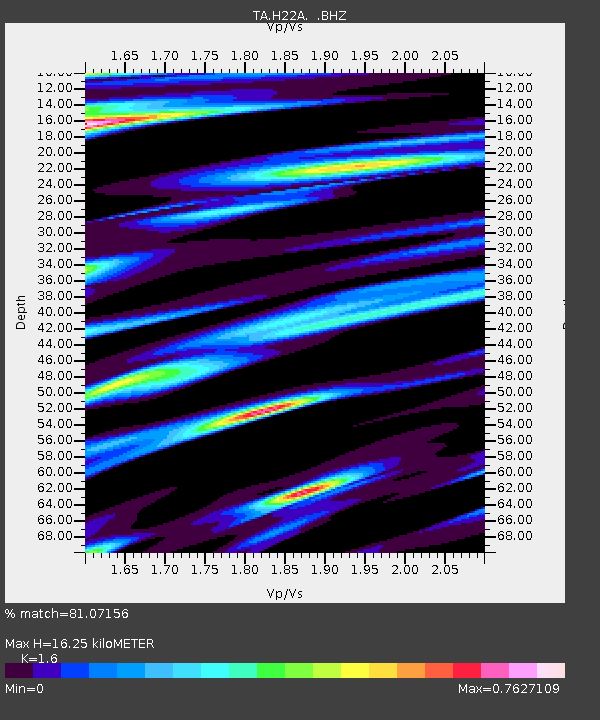
| Estimated Moho Depth: |
16.25 km |
| Estimated Crust Vp/Vs: |
1.60 |
| Assumed Crust Vp: |
6.178 km/s |
| Estimated Crust Vs: |
3.861 km/s |
| Estimated Crust Poisson's Ratio: |
0.18 |
|
| Radial Match: |
81.07156 % |
| Radial Bump: |
400 |
| Transverse Match: |
62.05812 % |
| Transverse Bump: |
400 |
| SOD ConfigId: |
2658 |
| Insert Time: |
2010-03-06 03:34:24.804 +0000 |
| GWidth: |
2.5 |
| Max Bumps: |
400 |
| Tol: |
0.001 |
|
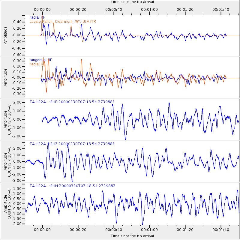
Signal To Noise
| Channel | StoN | STA | LTA |
| TA:H22A: :BHZ:20090330T07:18:54.273988Z | 9.043376 | 1.5303729E-6 | 1.6922584E-7 |
| TA:H22A: :BHN:20090330T07:18:54.273988Z | 1.1339709 | 4.1725391E-7 | 3.6795822E-7 |
| TA:H22A: :BHE:20090330T07:18:54.273988Z | 2.377727 | 7.1492224E-7 | 3.0067466E-7 |
| Arrivals |
| Ps | 1.7 SECOND |
| PpPs | 6.3 SECOND |
| PsPs/PpSs | 8.0 SECOND |


