You are here: Home > Network List > CI - Caltech Regional Seismic Network Stations List
> Station CHF Chilao Flat Rngr Sta, Altadena, CA, USA > Earthquake Result Viewer
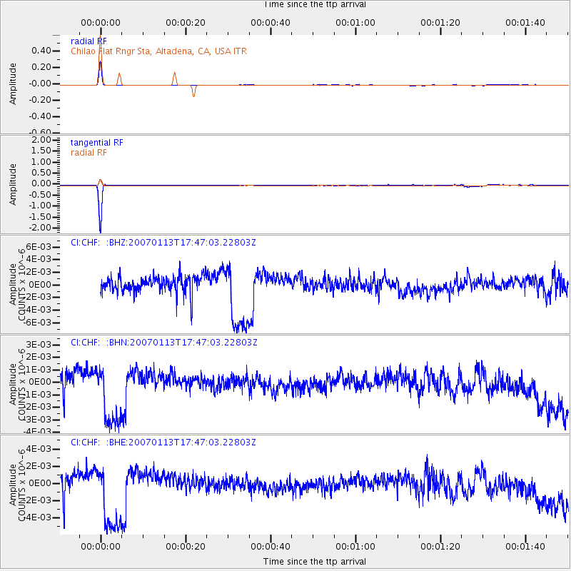
CHF Chilao Flat Rngr Sta, Altadena, CA, USA - Earthquake Result Viewer
| Earthquake location: |
East Of Kuril Islands |
| Earthquake latitude/longitude: |
46.9/156.3 |
| Earthquake time(UTC): |
2007/01/13 (013) 17:37:06 GMT |
| Earthquake Depth: |
10 km |
| Earthquake Magnitude: |
5.7 MB, 5.6 MS, 6.0 MW |
| Earthquake Catalog/Contributor: |
WHDF/NEIC |
|
| Network: |
CI Caltech Regional Seismic Network |
| Station: |
CHF Chilao Flat Rngr Sta, Altadena, CA, USA |
| Lat/Lon: |
34.33 N/118.03 W |
| Elevation: |
1594 m |
|
| Distance: |
63.2 deg |
| Az: |
67.625 deg |
| Baz: |
309.998 deg |
| Ray Param: |
0.05974806 |
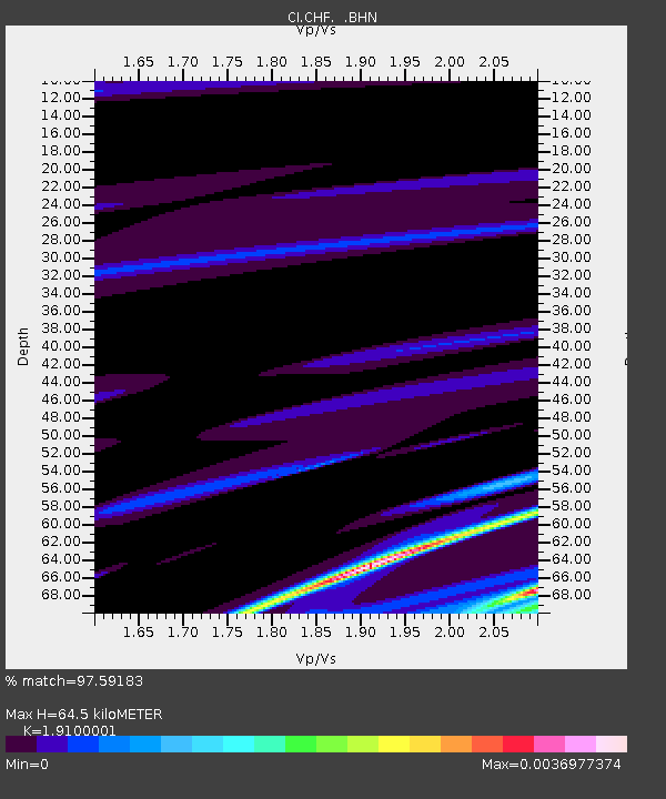
| Estimated Moho Depth: |
64.5 km |
| Estimated Crust Vp/Vs: |
1.91 |
| Assumed Crust Vp: |
6.1 km/s |
| Estimated Crust Vs: |
3.194 km/s |
| Estimated Crust Poisson's Ratio: |
0.31 |
|
| Radial Match: |
97.59183 % |
| Radial Bump: |
83 |
| Transverse Match: |
99.39175 % |
| Transverse Bump: |
85 |
| SOD ConfigId: |
2564 |
| Insert Time: |
2010-02-26 01:26:20.892 +0000 |
| GWidth: |
2.5 |
| Max Bumps: |
400 |
| Tol: |
0.001 |
|
Signal To Noise
| Channel | StoN | STA | LTA |
| CI:CHF: :BHN:20070113T17:47:03.22803Z | 4.4237533 | 2.7915983E-9 | 6.3104744E-10 |
| CI:CHF: :BHE:20070113T17:47:03.22803Z | 4.5138025 | 4.338867E-9 | 9.612443E-10 |
| CI:CHF: :BHZ:20070113T17:47:03.22803Z | 4.314803 | 5.6149045E-9 | 1.301312E-9 |
| Arrivals |
| Ps | 10.0 SECOND |
| PpPs | 30 SECOND |
| PsPs/PpSs | 40 SECOND |


