You are here: Home > Network List > AK - Alaska Regional Network Stations List
> Station GLI Glacier Island > Earthquake Result Viewer
GLI Glacier Island - Earthquake Result Viewer
| Earthquake location: |
Reykjanes Ridge |
| Earthquake latitude/longitude: |
57.1/-33.7 |
| Earthquake time(UTC): |
2017/09/10 (253) 21:40:21 GMT |
| Earthquake Depth: |
10 km |
| Earthquake Magnitude: |
5.9 Mww |
| Earthquake Catalog/Contributor: |
NEIC PDE/us |
|
| Network: |
AK Alaska Regional Network |
| Station: |
GLI Glacier Island |
| Lat/Lon: |
60.88 N/147.09 W |
| Elevation: |
430 m |
|
| Distance: |
51.3 deg |
| Az: |
324.898 deg |
| Baz: |
39.875 deg |
| Ray Param: |
0.067493066 |
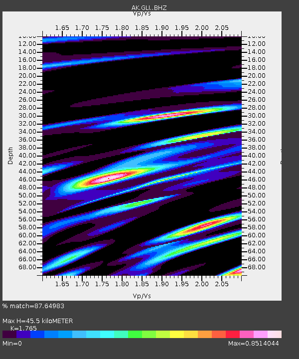
| Estimated Moho Depth: |
45.5 km |
| Estimated Crust Vp/Vs: |
1.76 |
| Assumed Crust Vp: |
6.566 km/s |
| Estimated Crust Vs: |
3.72 km/s |
| Estimated Crust Poisson's Ratio: |
0.26 |
|
| Radial Match: |
87.64983 % |
| Radial Bump: |
394 |
| Transverse Match: |
67.89349 % |
| Transverse Bump: |
400 |
| SOD ConfigId: |
13570011 |
| Insert Time: |
2019-04-28 18:19:08.089 +0000 |
| GWidth: |
2.5 |
| Max Bumps: |
400 |
| Tol: |
0.001 |
|

Signal To Noise
| Channel | StoN | STA | LTA |
| AK:GLI: :BHZ:20170910T21:48:54.488015Z | 3.8696659 | 5.6746296E-7 | 1.4664393E-7 |
| AK:GLI: :BHN:20170910T21:48:54.488015Z | 2.3200588 | 2.775306E-7 | 1.1962223E-7 |
| AK:GLI: :BHE:20170910T21:48:54.488015Z | 2.5182552 | 3.517669E-7 | 1.3968675E-7 |
| Arrivals |
| Ps | 5.6 SECOND |
| PpPs | 18 SECOND |
| PsPs/PpSs | 24 SECOND |


