You are here: Home > Network List > UU - University of Utah Regional Network Stations List
> Station FORU South Mineral Mountains, UT, USA > Earthquake Result Viewer
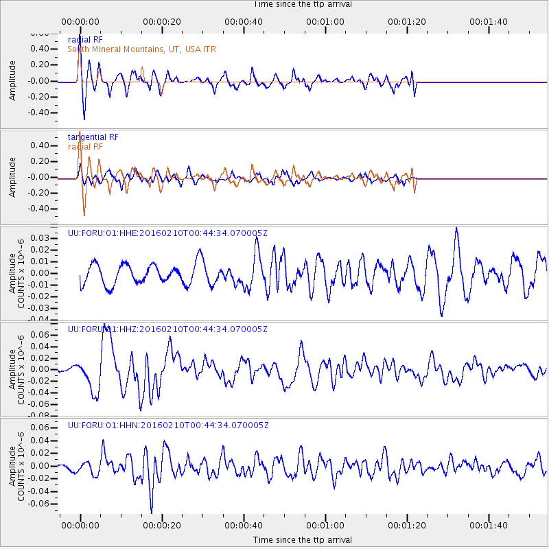
FORU South Mineral Mountains, UT, USA - Earthquake Result Viewer
*The percent match for this event was below the threshold and hence no stack was calculated.
| Earthquake location: |
Near Coast Of Central Chile |
| Earthquake latitude/longitude: |
-30.6/-71.6 |
| Earthquake time(UTC): |
2016/02/10 (041) 00:33:05 GMT |
| Earthquake Depth: |
32 km |
| Earthquake Magnitude: |
6.3 MWB |
| Earthquake Catalog/Contributor: |
NEIC PDE/NEIC COMCAT |
|
| Network: |
UU University of Utah Regional Network |
| Station: |
FORU South Mineral Mountains, UT, USA |
| Lat/Lon: |
38.46 N/112.86 W |
| Elevation: |
1840 m |
|
| Distance: |
78.8 deg |
| Az: |
328.152 deg |
| Baz: |
144.598 deg |
| Ray Param: |
$rayparam |
*The percent match for this event was below the threshold and hence was not used in the summary stack. |
|
| Radial Match: |
77.08361 % |
| Radial Bump: |
400 |
| Transverse Match: |
61.914753 % |
| Transverse Bump: |
382 |
| SOD ConfigId: |
1427151 |
| Insert Time: |
2016-02-24 01:05:01.734 +0000 |
| GWidth: |
2.5 |
| Max Bumps: |
400 |
| Tol: |
0.001 |
|
Signal To Noise
| Channel | StoN | STA | LTA |
| UU:FORU:01:HHZ:20160210T00:44:34.070005Z | 3.0494792 | 2.8820622E-8 | 9.450998E-9 |
| UU:FORU:01:HHN:20160210T00:44:34.070005Z | 1.6998583 | 9.583625E-9 | 5.637896E-9 |
| UU:FORU:01:HHE:20160210T00:44:34.070005Z | 1.402278 | 1.0911846E-8 | 7.781514E-9 |
| Arrivals |
| Ps | |
| PpPs | |
| PsPs/PpSs | |


