You are here: Home > Network List > AZ - ANZA Regional Network Stations List
> Station SMER AZ.SMER > Earthquake Result Viewer
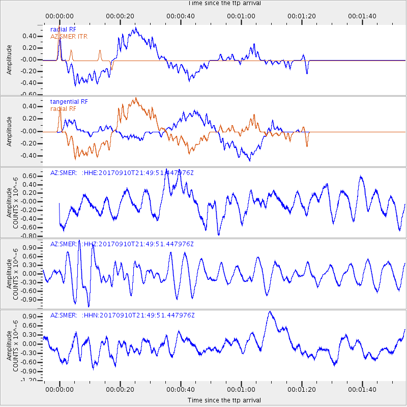
SMER AZ.SMER - Earthquake Result Viewer
*The percent match for this event was below the threshold and hence no stack was calculated.
| Earthquake location: |
Reykjanes Ridge |
| Earthquake latitude/longitude: |
57.1/-33.7 |
| Earthquake time(UTC): |
2017/09/10 (253) 21:40:21 GMT |
| Earthquake Depth: |
10 km |
| Earthquake Magnitude: |
5.9 Mww |
| Earthquake Catalog/Contributor: |
NEIC PDE/us |
|
| Network: |
AZ ANZA Regional Network |
| Station: |
SMER AZ.SMER |
| Lat/Lon: |
33.46 N/117.17 W |
| Elevation: |
355 m |
|
| Distance: |
59.2 deg |
| Az: |
284.826 deg |
| Baz: |
39.096 deg |
| Ray Param: |
$rayparam |
*The percent match for this event was below the threshold and hence was not used in the summary stack. |
|
| Radial Match: |
33.953857 % |
| Radial Bump: |
400 |
| Transverse Match: |
37.588562 % |
| Transverse Bump: |
400 |
| SOD ConfigId: |
13570011 |
| Insert Time: |
2019-04-28 18:20:12.073 +0000 |
| GWidth: |
2.5 |
| Max Bumps: |
400 |
| Tol: |
0.001 |
|
Signal To Noise
| Channel | StoN | STA | LTA |
| AZ:SMER: :HHZ:20170910T21:49:51.447976Z | 4.3788733 | 4.119314E-7 | 9.407247E-8 |
| AZ:SMER: :HHN:20170910T21:49:51.447976Z | 0.7901769 | 5.6603454E-7 | 7.16339E-7 |
| AZ:SMER: :HHE:20170910T21:49:51.447976Z | 1.2123381 | 2.7082802E-7 | 2.2339316E-7 |
| Arrivals |
| Ps | |
| PpPs | |
| PsPs/PpSs | |


