You are here: Home > Network List > TA - USArray Transportable Network (new EarthScope stations) Stations List
> Station H22A Lovato Ranch, Clearmont, WY, USA > Earthquake Result Viewer
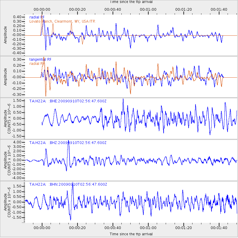
H22A Lovato Ranch, Clearmont, WY, USA - Earthquake Result Viewer
*The percent match for this event was below the threshold and hence no stack was calculated.
| Earthquake location: |
Kuril Islands |
| Earthquake latitude/longitude: |
48.3/154.2 |
| Earthquake time(UTC): |
2009/09/10 (253) 02:46:50 GMT |
| Earthquake Depth: |
36 km |
| Earthquake Magnitude: |
6.0 MB, 5.5 MS, 6.0 MW, 5.8 MW |
| Earthquake Catalog/Contributor: |
WHDF/NEIC |
|
| Network: |
TA USArray Transportable Network (new EarthScope stations) |
| Station: |
H22A Lovato Ranch, Clearmont, WY, USA |
| Lat/Lon: |
44.59 N/106.35 W |
| Elevation: |
1276 m |
|
| Distance: |
63.7 deg |
| Az: |
51.807 deg |
| Baz: |
312.753 deg |
| Ray Param: |
$rayparam |
*The percent match for this event was below the threshold and hence was not used in the summary stack. |
|
| Radial Match: |
79.39446 % |
| Radial Bump: |
400 |
| Transverse Match: |
64.576546 % |
| Transverse Bump: |
400 |
| SOD ConfigId: |
2622 |
| Insert Time: |
2010-03-06 03:34:55.078 +0000 |
| GWidth: |
2.5 |
| Max Bumps: |
400 |
| Tol: |
0.001 |
|
Signal To Noise
| Channel | StoN | STA | LTA |
| TA:H22A: :BHZ:20090910T02:56:47.600Z | 6.014837 | 9.899856E-7 | 1.6459059E-7 |
| TA:H22A: :BHN:20090910T02:56:47.600Z | 1.5083679 | 4.8037344E-7 | 3.1847233E-7 |
| TA:H22A: :BHE:20090910T02:56:47.600Z | 1.3914362 | 4.2011402E-7 | 3.0192834E-7 |
| Arrivals |
| Ps | |
| PpPs | |
| PsPs/PpSs | |


