You are here: Home > Network List > LD - Lamont-Doherty Cooperative Seismographic Network Stations List
> Station GEDE Greenville, DE, USA > Earthquake Result Viewer
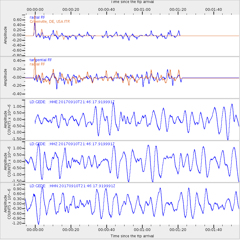
GEDE Greenville, DE, USA - Earthquake Result Viewer
*The percent match for this event was below the threshold and hence no stack was calculated.
| Earthquake location: |
Reykjanes Ridge |
| Earthquake latitude/longitude: |
57.1/-33.7 |
| Earthquake time(UTC): |
2017/09/10 (253) 21:40:21 GMT |
| Earthquake Depth: |
10 km |
| Earthquake Magnitude: |
5.9 Mww |
| Earthquake Catalog/Contributor: |
NEIC PDE/us |
|
| Network: |
LD Lamont-Doherty Cooperative Seismographic Network |
| Station: |
GEDE Greenville, DE, USA |
| Lat/Lon: |
39.81 N/75.64 W |
| Elevation: |
105 m |
|
| Distance: |
32.1 deg |
| Az: |
255.589 deg |
| Baz: |
43.292 deg |
| Ray Param: |
$rayparam |
*The percent match for this event was below the threshold and hence was not used in the summary stack. |
|
| Radial Match: |
66.052635 % |
| Radial Bump: |
366 |
| Transverse Match: |
52.271805 % |
| Transverse Bump: |
374 |
| SOD ConfigId: |
13570011 |
| Insert Time: |
2019-04-28 18:23:07.262 +0000 |
| GWidth: |
2.5 |
| Max Bumps: |
400 |
| Tol: |
0.001 |
|
Signal To Noise
| Channel | StoN | STA | LTA |
| LD:GEDE: :HHZ:20170910T21:46:17.919991Z | 2.6535053 | 8.2738154E-7 | 3.11807E-7 |
| LD:GEDE: :HHN:20170910T21:46:17.919991Z | 1.9122066 | 7.537442E-7 | 3.941751E-7 |
| LD:GEDE: :HHE:20170910T21:46:17.919991Z | 1.9898661 | 4.675614E-7 | 2.3497127E-7 |
| Arrivals |
| Ps | |
| PpPs | |
| PsPs/PpSs | |


