You are here: Home > Network List > G - GEOSCOPE Stations List
> Station ATD Arta Cave - Arta, Republic of Djibouti > Earthquake Result Viewer
ATD Arta Cave - Arta, Republic of Djibouti - Earthquake Result Viewer
| Earthquake location: |
Sumba Region, Indonesia |
| Earthquake latitude/longitude: |
-9.6/119.4 |
| Earthquake time(UTC): |
2016/02/12 (043) 10:02:24 GMT |
| Earthquake Depth: |
30 km |
| Earthquake Magnitude: |
6.5 MWP |
| Earthquake Catalog/Contributor: |
NEIC PDE/NEIC COMCAT |
|
| Network: |
G GEOSCOPE |
| Station: |
ATD Arta Cave - Arta, Republic of Djibouti |
| Lat/Lon: |
11.53 N/42.85 E |
| Elevation: |
610 m |
|
| Distance: |
78.9 deg |
| Az: |
283.769 deg |
| Baz: |
102.223 deg |
| Ray Param: |
0.049262054 |
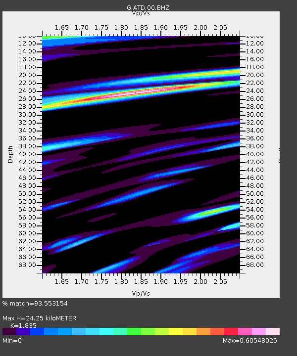
| Estimated Moho Depth: |
24.25 km |
| Estimated Crust Vp/Vs: |
1.84 |
| Assumed Crust Vp: |
6.375 km/s |
| Estimated Crust Vs: |
3.474 km/s |
| Estimated Crust Poisson's Ratio: |
0.29 |
|
| Radial Match: |
93.553154 % |
| Radial Bump: |
400 |
| Transverse Match: |
88.69458 % |
| Transverse Bump: |
400 |
| SOD ConfigId: |
1427151 |
| Insert Time: |
2016-02-26 10:22:24.624 +0000 |
| GWidth: |
2.5 |
| Max Bumps: |
400 |
| Tol: |
0.001 |
|
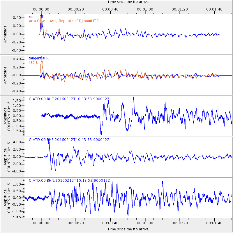
Signal To Noise
| Channel | StoN | STA | LTA |
| G:ATD:00:BHZ:20160212T10:13:53.900012Z | 21.24456 | 1.6471876E-6 | 7.753456E-8 |
| G:ATD:00:BHN:20160212T10:13:53.900012Z | 1.3329113 | 1.1383299E-7 | 8.540178E-8 |
| G:ATD:00:BHE:20160212T10:13:53.900012Z | 5.1505 | 6.038592E-7 | 1.1724284E-7 |
| Arrivals |
| Ps | 3.3 SECOND |
| PpPs | 10 SECOND |
| PsPs/PpSs | 14 SECOND |


