You are here: Home > Network List > TA - USArray Transportable Network (new EarthScope stations) Stations List
> Station H22A Lovato Ranch, Clearmont, WY, USA > Earthquake Result Viewer
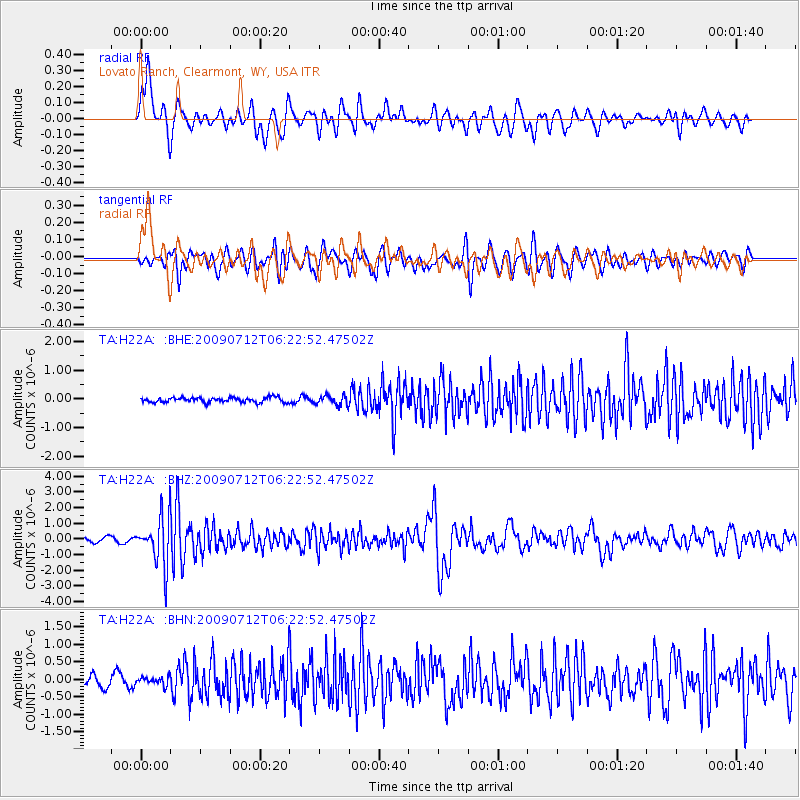
H22A Lovato Ranch, Clearmont, WY, USA - Earthquake Result Viewer
*The percent match for this event was below the threshold and hence no stack was calculated.
| Earthquake location: |
Southern Peru |
| Earthquake latitude/longitude: |
-15.0/-70.4 |
| Earthquake time(UTC): |
2009/07/12 (193) 06:12:47 GMT |
| Earthquake Depth: |
199 km |
| Earthquake Magnitude: |
5.7 MB, 6.1 MW, 6.1 MW |
| Earthquake Catalog/Contributor: |
WHDF/NEIC |
|
| Network: |
TA USArray Transportable Network (new EarthScope stations) |
| Station: |
H22A Lovato Ranch, Clearmont, WY, USA |
| Lat/Lon: |
44.59 N/106.35 W |
| Elevation: |
1276 m |
|
| Distance: |
67.7 deg |
| Az: |
333.082 deg |
| Baz: |
142.249 deg |
| Ray Param: |
$rayparam |
*The percent match for this event was below the threshold and hence was not used in the summary stack. |
|
| Radial Match: |
83.90309 % |
| Radial Bump: |
400 |
| Transverse Match: |
78.213554 % |
| Transverse Bump: |
400 |
| SOD ConfigId: |
2648 |
| Insert Time: |
2010-03-06 03:35:46.906 +0000 |
| GWidth: |
2.5 |
| Max Bumps: |
400 |
| Tol: |
0.001 |
|
Signal To Noise
| Channel | StoN | STA | LTA |
| TA:H22A: :BHZ:20090712T06:22:52.47502Z | 11.096249 | 1.5265591E-6 | 1.3757435E-7 |
| TA:H22A: :BHN:20090712T06:22:52.47502Z | 0.8199445 | 1.1367626E-7 | 1.3863897E-7 |
| TA:H22A: :BHE:20090712T06:22:52.47502Z | 1.9464431 | 1.6297429E-7 | 8.372928E-8 |
| Arrivals |
| Ps | |
| PpPs | |
| PsPs/PpSs | |


