You are here: Home > Network List > TA - USArray Transportable Network (new EarthScope stations) Stations List
> Station C16K Lisburne Hills, AK, USA > Earthquake Result Viewer
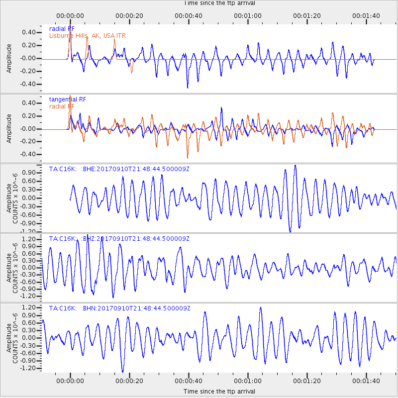
C16K Lisburne Hills, AK, USA - Earthquake Result Viewer
*The percent match for this event was below the threshold and hence no stack was calculated.
| Earthquake location: |
Reykjanes Ridge |
| Earthquake latitude/longitude: |
57.1/-33.7 |
| Earthquake time(UTC): |
2017/09/10 (253) 21:40:21 GMT |
| Earthquake Depth: |
10 km |
| Earthquake Magnitude: |
5.9 Mww |
| Earthquake Catalog/Contributor: |
NEIC PDE/us |
|
| Network: |
TA USArray Transportable Network (new EarthScope stations) |
| Station: |
C16K Lisburne Hills, AK, USA |
| Lat/Lon: |
68.27 N/165.34 W |
| Elevation: |
102 m |
|
| Distance: |
50.0 deg |
| Az: |
338.707 deg |
| Baz: |
32.135 deg |
| Ray Param: |
$rayparam |
*The percent match for this event was below the threshold and hence was not used in the summary stack. |
|
| Radial Match: |
78.08467 % |
| Radial Bump: |
400 |
| Transverse Match: |
73.93479 % |
| Transverse Bump: |
375 |
| SOD ConfigId: |
13570011 |
| Insert Time: |
2019-04-28 18:26:28.827 +0000 |
| GWidth: |
2.5 |
| Max Bumps: |
400 |
| Tol: |
0.001 |
|
Signal To Noise
| Channel | StoN | STA | LTA |
| TA:C16K: :BHZ:20170910T21:48:44.500009Z | 1.5463635 | 7.149049E-7 | 4.6231364E-7 |
| TA:C16K: :BHN:20170910T21:48:44.500009Z | 0.6135309 | 3.2311283E-7 | 5.266448E-7 |
| TA:C16K: :BHE:20170910T21:48:44.500009Z | 1.3843521 | 5.0269244E-7 | 3.631247E-7 |
| Arrivals |
| Ps | |
| PpPs | |
| PsPs/PpSs | |


