You are here: Home > Network List > TA - USArray Transportable Network (new EarthScope stations) Stations List
> Station E18K Tukpahlearik Creek, AK, USA > Earthquake Result Viewer
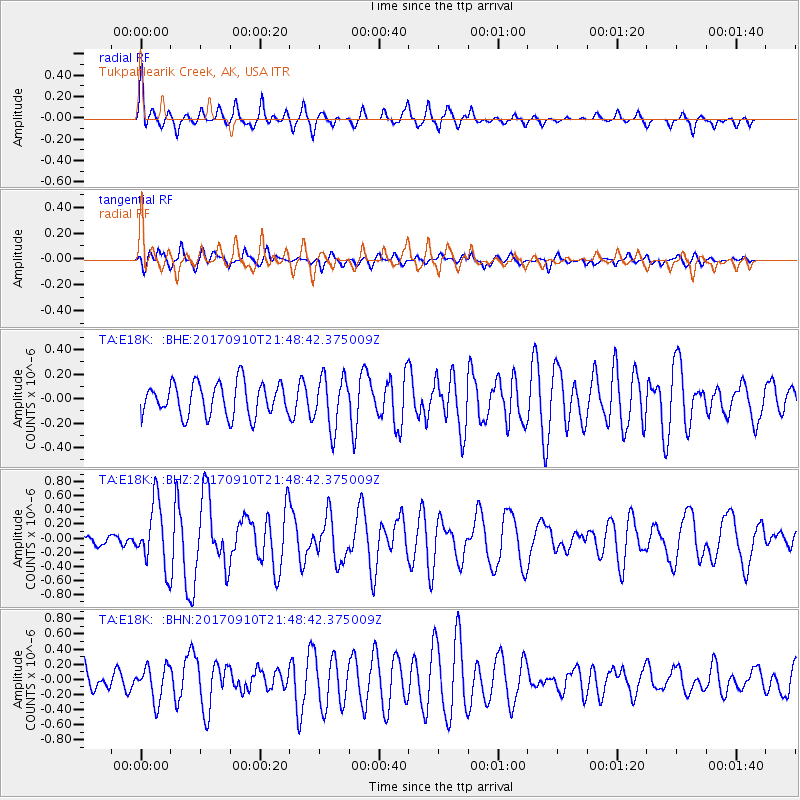
E18K Tukpahlearik Creek, AK, USA - Earthquake Result Viewer
*The percent match for this event was below the threshold and hence no stack was calculated.
| Earthquake location: |
Reykjanes Ridge |
| Earthquake latitude/longitude: |
57.1/-33.7 |
| Earthquake time(UTC): |
2017/09/10 (253) 21:40:21 GMT |
| Earthquake Depth: |
10 km |
| Earthquake Magnitude: |
5.9 Mww |
| Earthquake Catalog/Contributor: |
NEIC PDE/us |
|
| Network: |
TA USArray Transportable Network (new EarthScope stations) |
| Station: |
E18K Tukpahlearik Creek, AK, USA |
| Lat/Lon: |
67.42 N/160.60 W |
| Elevation: |
297 m |
|
| Distance: |
49.7 deg |
| Az: |
336.127 deg |
| Baz: |
34.858 deg |
| Ray Param: |
$rayparam |
*The percent match for this event was below the threshold and hence was not used in the summary stack. |
|
| Radial Match: |
54.81676 % |
| Radial Bump: |
336 |
| Transverse Match: |
63.069225 % |
| Transverse Bump: |
400 |
| SOD ConfigId: |
13570011 |
| Insert Time: |
2019-04-28 18:26:43.371 +0000 |
| GWidth: |
2.5 |
| Max Bumps: |
400 |
| Tol: |
0.001 |
|
Signal To Noise
| Channel | StoN | STA | LTA |
| TA:E18K: :BHZ:20170910T21:48:42.375009Z | 4.4352956 | 4.5257073E-7 | 1.02038456E-7 |
| TA:E18K: :BHN:20170910T21:48:42.375009Z | 1.4143244 | 2.2575135E-7 | 1.5961781E-7 |
| TA:E18K: :BHE:20170910T21:48:42.375009Z | 1.5605475 | 2.0911743E-7 | 1.340026E-7 |
| Arrivals |
| Ps | |
| PpPs | |
| PsPs/PpSs | |


