You are here: Home > Network List > TA - USArray Transportable Network (new EarthScope stations) Stations List
> Station TUL1 Leonard, OK, USA > Earthquake Result Viewer
TUL1 Leonard, OK, USA - Earthquake Result Viewer
| Earthquake location: |
East Of Kuril Islands |
| Earthquake latitude/longitude: |
46.9/155.2 |
| Earthquake time(UTC): |
2009/01/15 (015) 17:49:39 GMT |
| Earthquake Depth: |
36 km |
| Earthquake Magnitude: |
6.9 MB, 7.5 MS, 7.4 MW, 7.4 MW |
| Earthquake Catalog/Contributor: |
WHDF/NEIC |
|
| Network: |
TA USArray Transportable Network (new EarthScope stations) |
| Station: |
TUL1 Leonard, OK, USA |
| Lat/Lon: |
35.91 N/95.79 W |
| Elevation: |
256 m |
|
| Distance: |
75.9 deg |
| Az: |
52.279 deg |
| Baz: |
318.035 deg |
| Ray Param: |
0.05127209 |
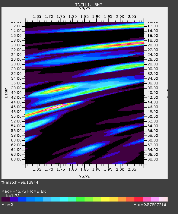
| Estimated Moho Depth: |
45.75 km |
| Estimated Crust Vp/Vs: |
1.73 |
| Assumed Crust Vp: |
6.498 km/s |
| Estimated Crust Vs: |
3.756 km/s |
| Estimated Crust Poisson's Ratio: |
0.25 |
|
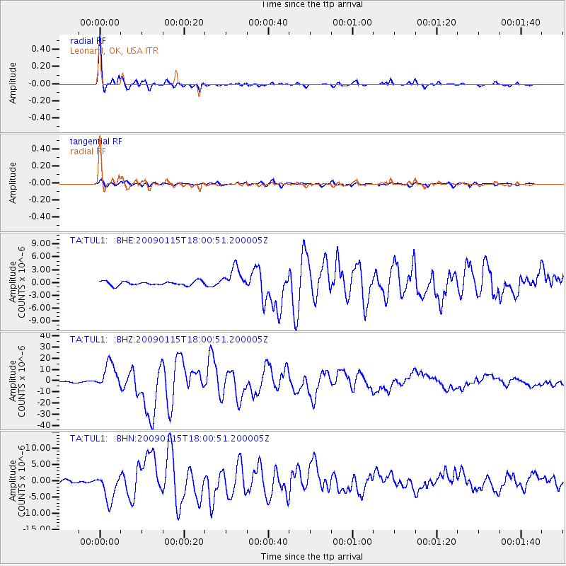
| Radial Match: |
98.13944 % |
| Radial Bump: |
315 |
| Transverse Match: |
79.18441 % |
| Transverse Bump: |
400 |
| SOD ConfigId: |
2834 |
| Insert Time: |
2010-03-06 03:36:05.193 +0000 |
| GWidth: |
2.5 |
| Max Bumps: |
400 |
| Tol: |
0.001 |
|
Signal To Noise
| Channel | StoN | STA | LTA |
| TA:TUL1: :BHZ:20090115T18:00:51.200005Z | 17.076977 | 1.1821575E-5 | 6.9225223E-7 |
| TA:TUL1: :BHN:20090115T18:00:51.200005Z | 7.594478 | 4.3110826E-6 | 5.6766015E-7 |
| TA:TUL1: :BHE:20090115T18:00:51.200005Z | 5.5171313 | 2.600154E-6 | 4.7128734E-7 |
| Arrivals |
| Ps | 5.3 SECOND |
| PpPs | 19 SECOND |
| PsPs/PpSs | 24 SECOND |


