You are here: Home > Network List > TA - USArray Transportable Network (new EarthScope stations) Stations List
> Station N20K Mount Spurr, AK, USA > Earthquake Result Viewer
N20K Mount Spurr, AK, USA - Earthquake Result Viewer
| Earthquake location: |
Reykjanes Ridge |
| Earthquake latitude/longitude: |
57.1/-33.7 |
| Earthquake time(UTC): |
2017/09/10 (253) 21:40:21 GMT |
| Earthquake Depth: |
10 km |
| Earthquake Magnitude: |
5.9 Mww |
| Earthquake Catalog/Contributor: |
NEIC PDE/us |
|
| Network: |
TA USArray Transportable Network (new EarthScope stations) |
| Station: |
N20K Mount Spurr, AK, USA |
| Lat/Lon: |
61.20 N/152.21 W |
| Elevation: |
991 m |
|
| Distance: |
52.6 deg |
| Az: |
327.625 deg |
| Baz: |
37.087 deg |
| Ray Param: |
0.06664956 |
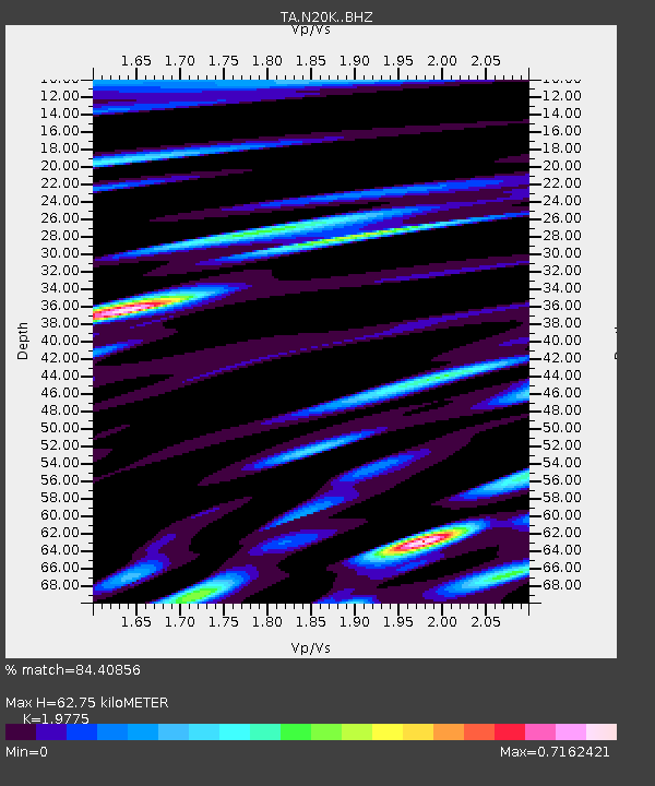
| Estimated Moho Depth: |
62.75 km |
| Estimated Crust Vp/Vs: |
1.98 |
| Assumed Crust Vp: |
6.566 km/s |
| Estimated Crust Vs: |
3.32 km/s |
| Estimated Crust Poisson's Ratio: |
0.33 |
|
| Radial Match: |
84.40856 % |
| Radial Bump: |
400 |
| Transverse Match: |
74.421265 % |
| Transverse Bump: |
400 |
| SOD ConfigId: |
13570011 |
| Insert Time: |
2019-04-28 18:28:00.694 +0000 |
| GWidth: |
2.5 |
| Max Bumps: |
400 |
| Tol: |
0.001 |
|

Signal To Noise
| Channel | StoN | STA | LTA |
| TA:N20K: :BHZ:20170910T21:49:04.124978Z | 8.17295 | 7.117929E-7 | 8.709131E-8 |
| TA:N20K: :BHN:20170910T21:49:04.124978Z | 3.551711 | 2.946871E-7 | 8.297046E-8 |
| TA:N20K: :BHE:20170910T21:49:04.124978Z | 3.2277873 | 2.900684E-7 | 8.986603E-8 |
| Arrivals |
| Ps | 9.8 SECOND |
| PpPs | 27 SECOND |
| PsPs/PpSs | 37 SECOND |


