You are here: Home > Network List > TA - USArray Transportable Network (new EarthScope stations) Stations List
> Station TUL1 Leonard, OK, USA > Earthquake Result Viewer
TUL1 Leonard, OK, USA - Earthquake Result Viewer
| Earthquake location: |
Near Coast Of Venezuela |
| Earthquake latitude/longitude: |
10.7/-67.9 |
| Earthquake time(UTC): |
2009/09/12 (255) 20:06:24 GMT |
| Earthquake Depth: |
10 km |
| Earthquake Magnitude: |
6.3 MB, 6.4 MS, 6.3 MW, 6.3 MW |
| Earthquake Catalog/Contributor: |
WHDF/NEIC |
|
| Network: |
TA USArray Transportable Network (new EarthScope stations) |
| Station: |
TUL1 Leonard, OK, USA |
| Lat/Lon: |
35.91 N/95.79 W |
| Elevation: |
256 m |
|
| Distance: |
35.6 deg |
| Az: |
319.315 deg |
| Baz: |
127.886 deg |
| Ray Param: |
0.077134386 |
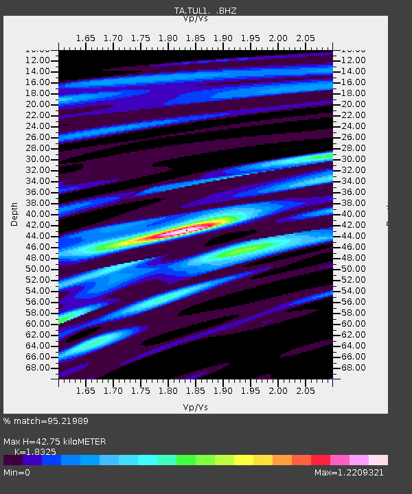
| Estimated Moho Depth: |
42.75 km |
| Estimated Crust Vp/Vs: |
1.83 |
| Assumed Crust Vp: |
6.498 km/s |
| Estimated Crust Vs: |
3.546 km/s |
| Estimated Crust Poisson's Ratio: |
0.29 |
|
| Radial Match: |
95.21989 % |
| Radial Bump: |
270 |
| Transverse Match: |
64.765594 % |
| Transverse Bump: |
400 |
| SOD ConfigId: |
2622 |
| Insert Time: |
2010-03-06 03:36:18.234 +0000 |
| GWidth: |
2.5 |
| Max Bumps: |
400 |
| Tol: |
0.001 |
|

Signal To Noise
| Channel | StoN | STA | LTA |
| TA:TUL1: :BHZ:20090912T20:12:51.550005Z | 12.241816 | 1.5821256E-6 | 1.2923945E-7 |
| TA:TUL1: :BHN:20090912T20:12:51.550005Z | 5.987695 | 7.437648E-7 | 1.2421555E-7 |
| TA:TUL1: :BHE:20090912T20:12:51.550005Z | 8.351307 | 9.837233E-7 | 1.17792744E-7 |
| Arrivals |
| Ps | 5.9 SECOND |
| PpPs | 17 SECOND |
| PsPs/PpSs | 23 SECOND |


