You are here: Home > Network List > TA - USArray Transportable Network (new EarthScope stations) Stations List
> Station R33M Jennings River, BC, CAN > Earthquake Result Viewer
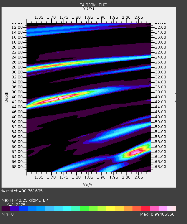
R33M Jennings River, BC, CAN - Earthquake Result Viewer
| Earthquake location: |
Reykjanes Ridge |
| Earthquake latitude/longitude: |
57.1/-33.7 |
| Earthquake time(UTC): |
2017/09/10 (253) 21:40:21 GMT |
| Earthquake Depth: |
10 km |
| Earthquake Magnitude: |
5.9 Mww |
| Earthquake Catalog/Contributor: |
NEIC PDE/us |
|
| Network: |
TA USArray Transportable Network (new EarthScope stations) |
| Station: |
R33M Jennings River, BC, CAN |
| Lat/Lon: |
59.39 N/130.97 W |
| Elevation: |
1437 m |
|
| Distance: |
46.8 deg |
| Az: |
315.86 deg |
| Baz: |
47.926 deg |
| Ray Param: |
0.070426516 |
| Estimated Moho Depth: |
40.25 km |
| Estimated Crust Vp/Vs: |
1.73 |
| Assumed Crust Vp: |
6.597 km/s |
| Estimated Crust Vs: |
3.819 km/s |
| Estimated Crust Poisson's Ratio: |
0.25 |
|
| Radial Match: |
80.761635 % |
| Radial Bump: |
282 |
| Transverse Match: |
58.17266 % |
| Transverse Bump: |
383 |
| SOD ConfigId: |
13570011 |
| Insert Time: |
2019-04-28 18:28:22.695 +0000 |
| GWidth: |
2.5 |
| Max Bumps: |
400 |
| Tol: |
0.001 |
|

Signal To Noise
| Channel | StoN | STA | LTA |
| TA:R33M: :BHZ:20170910T21:48:19.82499Z | 2.4792962 | 5.81532E-7 | 2.3455527E-7 |
| TA:R33M: :BHN:20170910T21:48:19.82499Z | 1.1311371 | 2.8755852E-7 | 2.5422074E-7 |
| TA:R33M: :BHE:20170910T21:48:19.82499Z | 1.583533 | 3.02455E-7 | 1.9100011E-7 |
| Arrivals |
| Ps | 4.7 SECOND |
| PpPs | 16 SECOND |
| PsPs/PpSs | 20 SECOND |


