You are here: Home > Network List > TA - USArray Transportable Network (new EarthScope stations) Stations List
> Station TPFO Pinon Flats, CA, USA > Earthquake Result Viewer
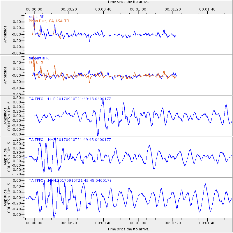
TPFO Pinon Flats, CA, USA - Earthquake Result Viewer
*The percent match for this event was below the threshold and hence no stack was calculated.
| Earthquake location: |
Reykjanes Ridge |
| Earthquake latitude/longitude: |
57.1/-33.7 |
| Earthquake time(UTC): |
2017/09/10 (253) 21:40:21 GMT |
| Earthquake Depth: |
10 km |
| Earthquake Magnitude: |
5.9 Mww |
| Earthquake Catalog/Contributor: |
NEIC PDE/us |
|
| Network: |
TA USArray Transportable Network (new EarthScope stations) |
| Station: |
TPFO Pinon Flats, CA, USA |
| Lat/Lon: |
33.61 N/116.45 W |
| Elevation: |
1275 m |
|
| Distance: |
58.7 deg |
| Az: |
284.394 deg |
| Baz: |
39.267 deg |
| Ray Param: |
$rayparam |
*The percent match for this event was below the threshold and hence was not used in the summary stack. |
|
| Radial Match: |
64.17723 % |
| Radial Bump: |
307 |
| Transverse Match: |
49.048946 % |
| Transverse Bump: |
400 |
| SOD ConfigId: |
13570011 |
| Insert Time: |
2019-04-28 18:28:28.499 +0000 |
| GWidth: |
2.5 |
| Max Bumps: |
400 |
| Tol: |
0.001 |
|
Signal To Noise
| Channel | StoN | STA | LTA |
| TA:TPFO: :HHZ:20170910T21:49:48.040017Z | 4.230965 | 4.6411637E-7 | 1.09695144E-7 |
| TA:TPFO: :HHN:20170910T21:49:48.040017Z | 2.2188253 | 2.4407362E-7 | 1.10001274E-7 |
| TA:TPFO: :HHE:20170910T21:49:48.040017Z | 1.5103204 | 1.7747526E-7 | 1.1750835E-7 |
| Arrivals |
| Ps | |
| PpPs | |
| PsPs/PpSs | |


