You are here: Home > Network List > UW - Pacific Northwest Regional Seismic Network Stations List
> Station YACT Amboy, WA, USA > Earthquake Result Viewer
YACT Amboy, WA, USA - Earthquake Result Viewer
*The percent match for this event was below the threshold and hence no stack was calculated.
| Earthquake location: |
Reykjanes Ridge |
| Earthquake latitude/longitude: |
57.1/-33.7 |
| Earthquake time(UTC): |
2017/09/10 (253) 21:40:21 GMT |
| Earthquake Depth: |
10 km |
| Earthquake Magnitude: |
5.9 Mww |
| Earthquake Catalog/Contributor: |
NEIC PDE/us |
|
| Network: |
UW Pacific Northwest Regional Seismic Network |
| Station: |
YACT Amboy, WA, USA |
| Lat/Lon: |
45.93 N/122.42 W |
| Elevation: |
211 m |
|
| Distance: |
52.5 deg |
| Az: |
298.429 deg |
| Baz: |
43.406 deg |
| Ray Param: |
$rayparam |
*The percent match for this event was below the threshold and hence was not used in the summary stack. |
|
| Radial Match: |
48.128002 % |
| Radial Bump: |
387 |
| Transverse Match: |
59.75492 % |
| Transverse Bump: |
400 |
| SOD ConfigId: |
13570011 |
| Insert Time: |
2019-04-28 18:29:28.450 +0000 |
| GWidth: |
2.5 |
| Max Bumps: |
400 |
| Tol: |
0.001 |
|
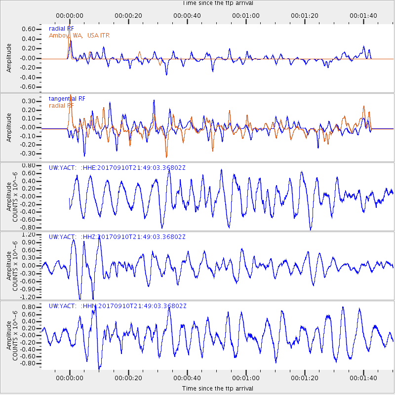
Signal To Noise
| Channel | StoN | STA | LTA |
| UW:YACT: :HHZ:20170910T21:49:03.36802Z | 3.6497524 | 7.3485313E-7 | 2.0134328E-7 |
| UW:YACT: :HHN:20170910T21:49:03.36802Z | 1.4533917 | 2.655625E-7 | 1.8271916E-7 |
| UW:YACT: :HHE:20170910T21:49:03.36802Z | 1.5705694 | 4.74659E-7 | 3.0222097E-7 |
| Arrivals |
| Ps | |
| PpPs | |
| PsPs/PpSs | |


