You are here: Home > Network List > CI - Caltech Regional Seismic Network Stations List
> Station TIN Tinemaha, Big Pine, CA, USA > Earthquake Result Viewer
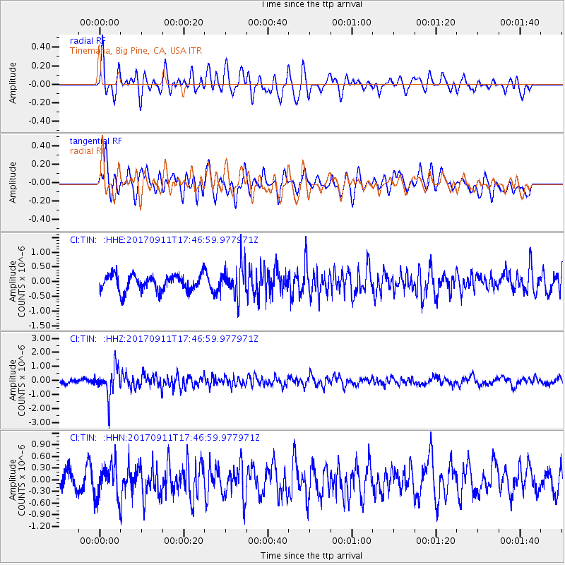
TIN Tinemaha, Big Pine, CA, USA - Earthquake Result Viewer
*The percent match for this event was below the threshold and hence no stack was calculated.
| Earthquake location: |
Volcano Islands, Japan Region |
| Earthquake latitude/longitude: |
24.0/142.3 |
| Earthquake time(UTC): |
2017/09/11 (254) 17:35:09 GMT |
| Earthquake Depth: |
35 km |
| Earthquake Magnitude: |
5.7 Mww |
| Earthquake Catalog/Contributor: |
NEIC PDE/us |
|
| Network: |
CI Caltech Regional Seismic Network |
| Station: |
TIN Tinemaha, Big Pine, CA, USA |
| Lat/Lon: |
37.05 N/118.23 W |
| Elevation: |
1197 m |
|
| Distance: |
83.0 deg |
| Az: |
52.67 deg |
| Baz: |
294.586 deg |
| Ray Param: |
$rayparam |
*The percent match for this event was below the threshold and hence was not used in the summary stack. |
|
| Radial Match: |
62.884384 % |
| Radial Bump: |
400 |
| Transverse Match: |
70.943924 % |
| Transverse Bump: |
400 |
| SOD ConfigId: |
13570011 |
| Insert Time: |
2019-04-28 18:34:00.718 +0000 |
| GWidth: |
2.5 |
| Max Bumps: |
400 |
| Tol: |
0.001 |
|
Signal To Noise
| Channel | StoN | STA | LTA |
| CI:TIN: :HHZ:20170911T17:46:59.977971Z | 4.7307534 | 1.0460648E-6 | 2.2112013E-7 |
| CI:TIN: :HHN:20170911T17:46:59.977971Z | 1.6422647 | 4.1987929E-7 | 2.556709E-7 |
| CI:TIN: :HHE:20170911T17:46:59.977971Z | 1.9965063 | 5.4175945E-7 | 2.7135374E-7 |
| Arrivals |
| Ps | |
| PpPs | |
| PsPs/PpSs | |


