You are here: Home > Network List > II - Global Seismograph Network (GSN - IRIS/IDA) Stations List
> Station WRAB Tennant Creek, NT, Australia > Earthquake Result Viewer
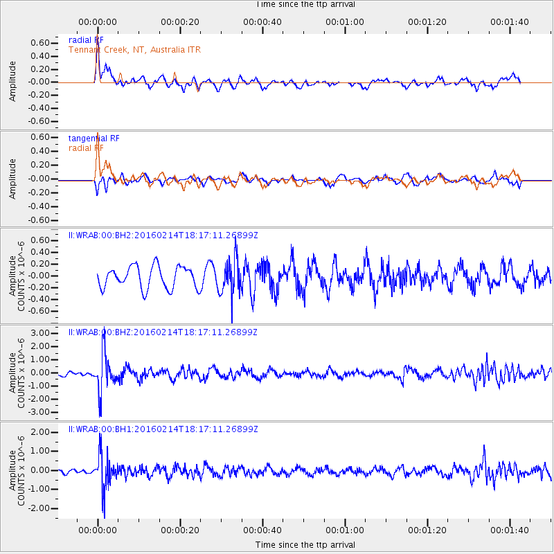
WRAB Tennant Creek, NT, Australia - Earthquake Result Viewer
*The percent match for this event was below the threshold and hence no stack was calculated.
| Earthquake location: |
Southeast Of Honshu, Japan |
| Earthquake latitude/longitude: |
30.3/138.9 |
| Earthquake time(UTC): |
2016/02/14 (045) 18:09:26 GMT |
| Earthquake Depth: |
413 km |
| Earthquake Magnitude: |
5.7 MB |
| Earthquake Catalog/Contributor: |
NEIC PDE/NEIC COMCAT |
|
| Network: |
II Global Seismograph Network (GSN - IRIS/IDA) |
| Station: |
WRAB Tennant Creek, NT, Australia |
| Lat/Lon: |
19.93 S/134.36 E |
| Elevation: |
366 m |
|
| Distance: |
50.1 deg |
| Az: |
185.507 deg |
| Baz: |
5.061 deg |
| Ray Param: |
$rayparam |
*The percent match for this event was below the threshold and hence was not used in the summary stack. |
|
| Radial Match: |
78.651375 % |
| Radial Bump: |
400 |
| Transverse Match: |
55.37226 % |
| Transverse Bump: |
400 |
| SOD ConfigId: |
1427151 |
| Insert Time: |
2016-02-28 18:56:21.488 +0000 |
| GWidth: |
2.5 |
| Max Bumps: |
400 |
| Tol: |
0.001 |
|
Signal To Noise
| Channel | StoN | STA | LTA |
| II:WRAB:00:BHZ:20160214T18:17:11.26899Z | 8.659571 | 1.4606969E-6 | 1.6868005E-7 |
| II:WRAB:00:BH1:20160214T18:17:11.26899Z | 5.552517 | 8.899055E-7 | 1.6027064E-7 |
| II:WRAB:00:BH2:20160214T18:17:11.26899Z | 1.6264524 | 2.9953785E-7 | 1.8416637E-7 |
| Arrivals |
| Ps | |
| PpPs | |
| PsPs/PpSs | |


