You are here: Home > Network List > TA - USArray Transportable Network (new EarthScope stations) Stations List
> Station E22K Anaktuvuk Pass, AK, USA > Earthquake Result Viewer
E22K Anaktuvuk Pass, AK, USA - Earthquake Result Viewer
| Earthquake location: |
Volcano Islands, Japan Region |
| Earthquake latitude/longitude: |
24.0/142.3 |
| Earthquake time(UTC): |
2017/09/11 (254) 17:35:09 GMT |
| Earthquake Depth: |
35 km |
| Earthquake Magnitude: |
5.7 Mww |
| Earthquake Catalog/Contributor: |
NEIC PDE/us |
|
| Network: |
TA USArray Transportable Network (new EarthScope stations) |
| Station: |
E22K Anaktuvuk Pass, AK, USA |
| Lat/Lon: |
68.13 N/151.81 W |
| Elevation: |
772 m |
|
| Distance: |
59.0 deg |
| Az: |
23.492 deg |
| Baz: |
256.798 deg |
| Ray Param: |
0.062392667 |
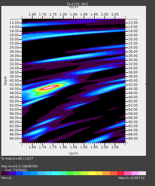
| Estimated Moho Depth: |
43.0 km |
| Estimated Crust Vp/Vs: |
1.73 |
| Assumed Crust Vp: |
6.221 km/s |
| Estimated Crust Vs: |
3.591 km/s |
| Estimated Crust Poisson's Ratio: |
0.25 |
|
| Radial Match: |
88.11637 % |
| Radial Bump: |
400 |
| Transverse Match: |
75.33283 % |
| Transverse Bump: |
400 |
| SOD ConfigId: |
13570011 |
| Insert Time: |
2019-04-28 18:37:55.004 +0000 |
| GWidth: |
2.5 |
| Max Bumps: |
400 |
| Tol: |
0.001 |
|

Signal To Noise
| Channel | StoN | STA | LTA |
| TA:E22K: :BHZ:20170911T17:44:35.34998Z | 14.255542 | 9.722331E-7 | 6.8200364E-8 |
| TA:E22K: :BHN:20170911T17:44:35.34998Z | 1.983588 | 1.6349252E-7 | 8.242262E-8 |
| TA:E22K: :BHE:20170911T17:44:35.34998Z | 6.087324 | 3.9354796E-7 | 6.465041E-8 |
| Arrivals |
| Ps | 5.3 SECOND |
| PpPs | 18 SECOND |
| PsPs/PpSs | 23 SECOND |


