You are here: Home > Network List > IU - Global Seismograph Network (GSN - IRIS/USGS) Stations List
> Station CTAO Charters Towers, Australia > Earthquake Result Viewer
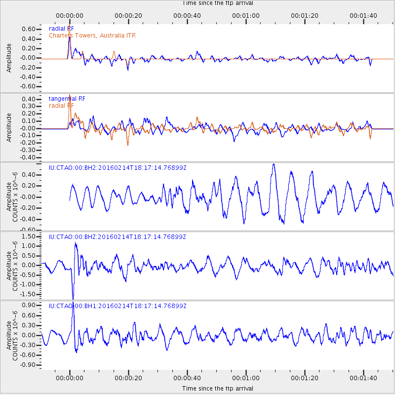
CTAO Charters Towers, Australia - Earthquake Result Viewer
*The percent match for this event was below the threshold and hence no stack was calculated.
| Earthquake location: |
Southeast Of Honshu, Japan |
| Earthquake latitude/longitude: |
30.3/138.9 |
| Earthquake time(UTC): |
2016/02/14 (045) 18:09:26 GMT |
| Earthquake Depth: |
413 km |
| Earthquake Magnitude: |
5.7 MB |
| Earthquake Catalog/Contributor: |
NEIC PDE/NEIC COMCAT |
|
| Network: |
IU Global Seismograph Network (GSN - IRIS/USGS) |
| Station: |
CTAO Charters Towers, Australia |
| Lat/Lon: |
20.09 S/146.25 E |
| Elevation: |
357 m |
|
| Distance: |
50.6 deg |
| Az: |
170.982 deg |
| Baz: |
351.707 deg |
| Ray Param: |
$rayparam |
*The percent match for this event was below the threshold and hence was not used in the summary stack. |
|
| Radial Match: |
53.494396 % |
| Radial Bump: |
400 |
| Transverse Match: |
75.0893 % |
| Transverse Bump: |
393 |
| SOD ConfigId: |
1427151 |
| Insert Time: |
2016-02-28 18:56:49.033 +0000 |
| GWidth: |
2.5 |
| Max Bumps: |
400 |
| Tol: |
0.001 |
|
Signal To Noise
| Channel | StoN | STA | LTA |
| IU:CTAO:00:BHZ:20160214T18:17:14.76899Z | 5.3301845 | 7.107701E-7 | 1.3334812E-7 |
| IU:CTAO:00:BH1:20160214T18:17:14.76899Z | 2.6904945 | 3.791639E-7 | 1.4092721E-7 |
| IU:CTAO:00:BH2:20160214T18:17:14.76899Z | 0.82462245 | 1.05215584E-7 | 1.2759244E-7 |
| Arrivals |
| Ps | |
| PpPs | |
| PsPs/PpSs | |


