You are here: Home > Network List > IU - Global Seismograph Network (GSN - IRIS/USGS) Stations List
> Station MAKZ Makanchi, Kazakhstan > Earthquake Result Viewer
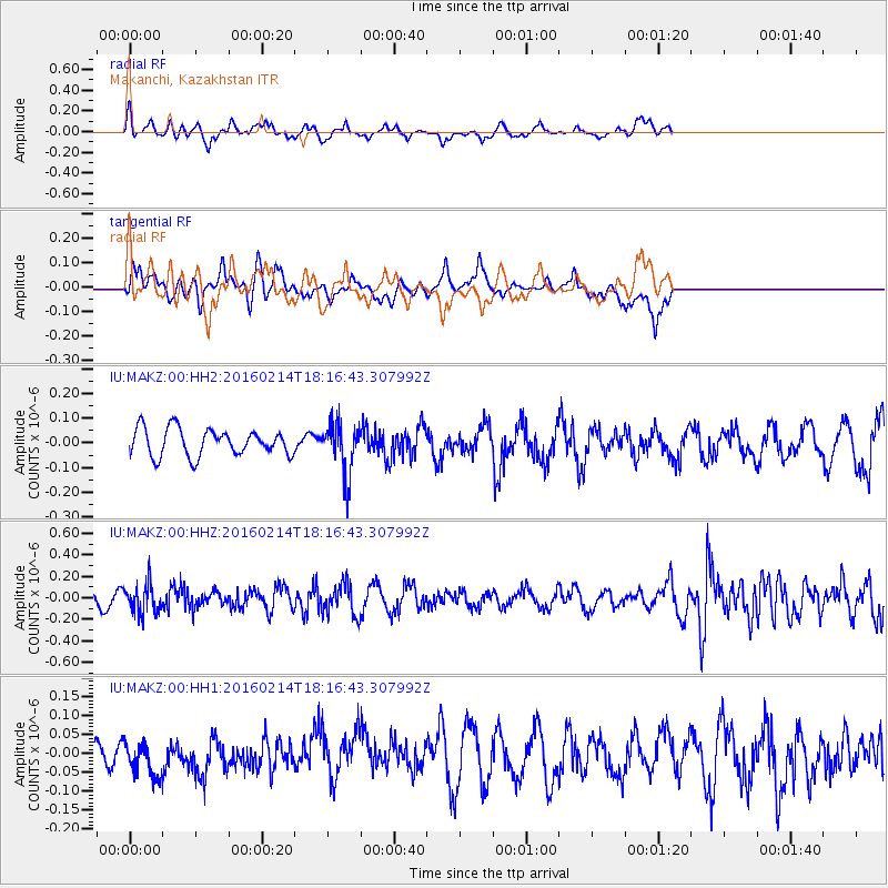
MAKZ Makanchi, Kazakhstan - Earthquake Result Viewer
*The percent match for this event was below the threshold and hence no stack was calculated.
| Earthquake location: |
Southeast Of Honshu, Japan |
| Earthquake latitude/longitude: |
30.3/138.9 |
| Earthquake time(UTC): |
2016/02/14 (045) 18:09:26 GMT |
| Earthquake Depth: |
413 km |
| Earthquake Magnitude: |
5.7 MB |
| Earthquake Catalog/Contributor: |
NEIC PDE/NEIC COMCAT |
|
| Network: |
IU Global Seismograph Network (GSN - IRIS/USGS) |
| Station: |
MAKZ Makanchi, Kazakhstan |
| Lat/Lon: |
46.81 N/81.98 E |
| Elevation: |
600 m |
|
| Distance: |
46.4 deg |
| Az: |
307.418 deg |
| Baz: |
89.894 deg |
| Ray Param: |
$rayparam |
*The percent match for this event was below the threshold and hence was not used in the summary stack. |
|
| Radial Match: |
64.01328 % |
| Radial Bump: |
376 |
| Transverse Match: |
61.793167 % |
| Transverse Bump: |
400 |
| SOD ConfigId: |
1427151 |
| Insert Time: |
2016-02-28 18:57:22.617 +0000 |
| GWidth: |
2.5 |
| Max Bumps: |
400 |
| Tol: |
0.001 |
|
Signal To Noise
| Channel | StoN | STA | LTA |
| IU:MAKZ:00:HHZ:20160214T18:16:43.307992Z | 1.9369974 | 1.3716239E-7 | 7.0811865E-8 |
| IU:MAKZ:00:HH1:20160214T18:16:43.307992Z | 1.1258143 | 4.411633E-8 | 3.918615E-8 |
| IU:MAKZ:00:HH2:20160214T18:16:43.307992Z | 1.9259084 | 1.050059E-7 | 5.452279E-8 |
| Arrivals |
| Ps | |
| PpPs | |
| PsPs/PpSs | |


