You are here: Home > Network List > TA - USArray Transportable Network (new EarthScope stations) Stations List
> Station I22A 9 Mile Ranch, Kaycee, WY, USA > Earthquake Result Viewer
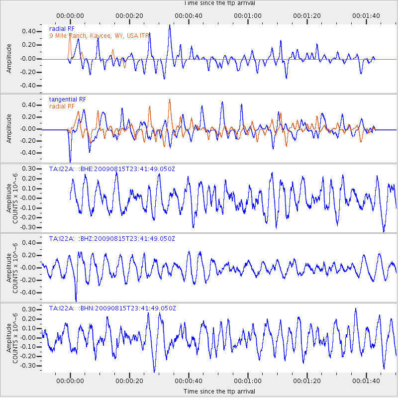
I22A 9 Mile Ranch, Kaycee, WY, USA - Earthquake Result Viewer
*The percent match for this event was below the threshold and hence no stack was calculated.
| Earthquake location: |
Fiji Islands Region |
| Earthquake latitude/longitude: |
-19.8/-178.2 |
| Earthquake time(UTC): |
2009/08/15 (227) 23:30:19 GMT |
| Earthquake Depth: |
608 km |
| Earthquake Magnitude: |
5.6 MW, 5.2 MB |
| Earthquake Catalog/Contributor: |
WHDF/NEIC |
|
| Network: |
TA USArray Transportable Network (new EarthScope stations) |
| Station: |
I22A 9 Mile Ranch, Kaycee, WY, USA |
| Lat/Lon: |
43.89 N/106.48 W |
| Elevation: |
1430 m |
|
| Distance: |
91.1 deg |
| Az: |
43.374 deg |
| Baz: |
243.418 deg |
| Ray Param: |
$rayparam |
*The percent match for this event was below the threshold and hence was not used in the summary stack. |
|
| Radial Match: |
66.32127 % |
| Radial Bump: |
400 |
| Transverse Match: |
67.06404 % |
| Transverse Bump: |
400 |
| SOD ConfigId: |
2622 |
| Insert Time: |
2010-03-06 03:38:14.068 +0000 |
| GWidth: |
2.5 |
| Max Bumps: |
400 |
| Tol: |
0.001 |
|
Signal To Noise
| Channel | StoN | STA | LTA |
| TA:I22A: :BHZ:20090815T23:41:49.050Z | 1.858085 | 2.0995628E-7 | 1.1299606E-7 |
| TA:I22A: :BHN:20090815T23:41:49.050Z | 0.9148246 | 1.03386164E-7 | 1.13012014E-7 |
| TA:I22A: :BHE:20090815T23:41:49.050Z | 1.0627506 | 1.2093766E-7 | 1.1379684E-7 |
| Arrivals |
| Ps | |
| PpPs | |
| PsPs/PpSs | |


