You are here: Home > Network List > TA - USArray Transportable Network (new EarthScope stations) Stations List
> Station H27K Steamboat Mountain, AK, USA > Earthquake Result Viewer
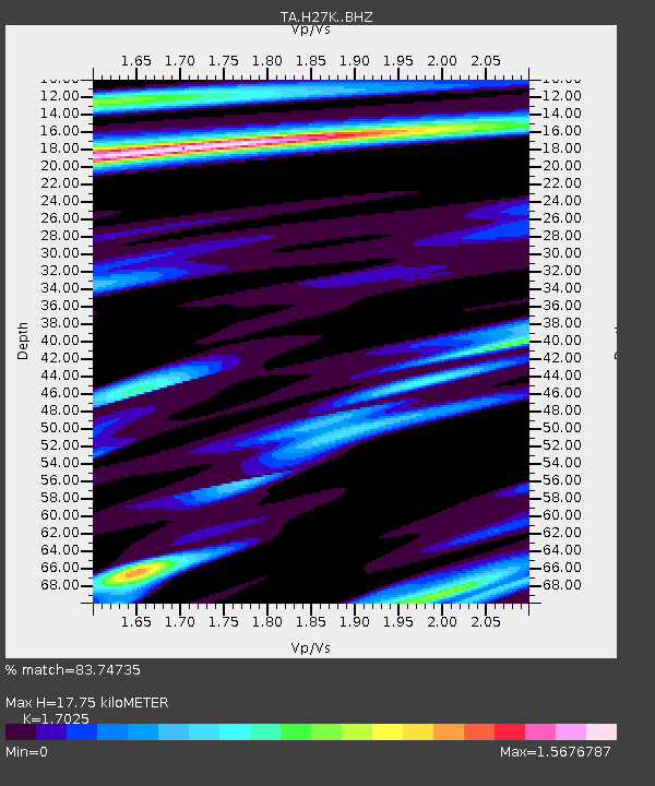
H27K Steamboat Mountain, AK, USA - Earthquake Result Viewer
| Earthquake location: |
Volcano Islands, Japan Region |
| Earthquake latitude/longitude: |
24.0/142.3 |
| Earthquake time(UTC): |
2017/09/11 (254) 17:35:09 GMT |
| Earthquake Depth: |
35 km |
| Earthquake Magnitude: |
5.7 Mww |
| Earthquake Catalog/Contributor: |
NEIC PDE/us |
|
| Network: |
TA USArray Transportable Network (new EarthScope stations) |
| Station: |
H27K Steamboat Mountain, AK, USA |
| Lat/Lon: |
66.23 N/141.53 W |
| Elevation: |
786 m |
|
| Distance: |
62.7 deg |
| Az: |
26.274 deg |
| Baz: |
267.63 deg |
| Ray Param: |
0.059965305 |
| Estimated Moho Depth: |
17.75 km |
| Estimated Crust Vp/Vs: |
1.70 |
| Assumed Crust Vp: |
6.577 km/s |
| Estimated Crust Vs: |
3.863 km/s |
| Estimated Crust Poisson's Ratio: |
0.24 |
|
| Radial Match: |
83.74735 % |
| Radial Bump: |
400 |
| Transverse Match: |
71.17919 % |
| Transverse Bump: |
400 |
| SOD ConfigId: |
13570011 |
| Insert Time: |
2019-04-28 18:38:28.616 +0000 |
| GWidth: |
2.5 |
| Max Bumps: |
400 |
| Tol: |
0.001 |
|

Signal To Noise
| Channel | StoN | STA | LTA |
| TA:H27K: :BHZ:20170911T17:45:00.500005Z | 9.961058 | 1.1751484E-6 | 1.1797427E-7 |
| TA:H27K: :BHN:20170911T17:45:00.500005Z | 1.8055425 | 3.1637776E-7 | 1.7522588E-7 |
| TA:H27K: :BHE:20170911T17:45:00.500005Z | 3.7767985 | 5.887662E-7 | 1.558903E-7 |
| Arrivals |
| Ps | 2.0 SECOND |
| PpPs | 7.0 SECOND |
| PsPs/PpSs | 8.9 SECOND |


