You are here: Home > Network List > TA - USArray Transportable Network (new EarthScope stations) Stations List
> Station N23A Red Feather Lakes, CO, USA > Earthquake Result Viewer
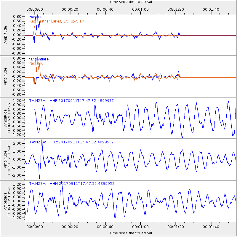
N23A Red Feather Lakes, CO, USA - Earthquake Result Viewer
*The percent match for this event was below the threshold and hence no stack was calculated.
| Earthquake location: |
Volcano Islands, Japan Region |
| Earthquake latitude/longitude: |
24.0/142.3 |
| Earthquake time(UTC): |
2017/09/11 (254) 17:35:09 GMT |
| Earthquake Depth: |
35 km |
| Earthquake Magnitude: |
5.7 Mww |
| Earthquake Catalog/Contributor: |
NEIC PDE/us |
|
| Network: |
TA USArray Transportable Network (new EarthScope stations) |
| Station: |
N23A Red Feather Lakes, CO, USA |
| Lat/Lon: |
40.89 N/105.94 W |
| Elevation: |
2458 m |
|
| Distance: |
89.6 deg |
| Az: |
44.772 deg |
| Baz: |
301.793 deg |
| Ray Param: |
$rayparam |
*The percent match for this event was below the threshold and hence was not used in the summary stack. |
|
| Radial Match: |
76.896774 % |
| Radial Bump: |
330 |
| Transverse Match: |
57.565025 % |
| Transverse Bump: |
327 |
| SOD ConfigId: |
13570011 |
| Insert Time: |
2019-04-28 18:39:18.103 +0000 |
| GWidth: |
2.5 |
| Max Bumps: |
400 |
| Tol: |
0.001 |
|
Signal To Noise
| Channel | StoN | STA | LTA |
| TA:N23A: :HHZ:20170911T17:47:32.489995Z | 3.5363543 | 1.1340132E-6 | 3.2067297E-7 |
| TA:N23A: :HHN:20170911T17:47:32.489995Z | 1.1630265 | 5.1816244E-7 | 4.4552937E-7 |
| TA:N23A: :HHE:20170911T17:47:32.489995Z | 1.252376 | 5.3422133E-7 | 4.2656626E-7 |
| Arrivals |
| Ps | |
| PpPs | |
| PsPs/PpSs | |


