You are here: Home > Network List > TA - USArray Transportable Network (new EarthScope stations) Stations List
> Station I22A 9 Mile Ranch, Kaycee, WY, USA > Earthquake Result Viewer
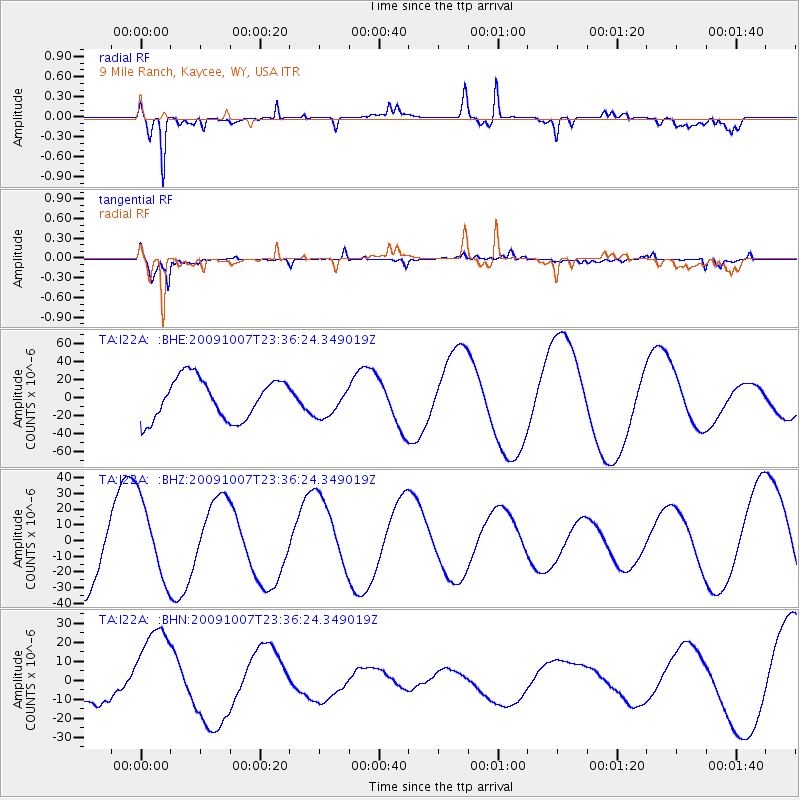
I22A 9 Mile Ranch, Kaycee, WY, USA - Earthquake Result Viewer
*The percent match for this event was below the threshold and hence no stack was calculated.
| Earthquake location: |
Santa Cruz Islands |
| Earthquake latitude/longitude: |
-12.6/166.0 |
| Earthquake time(UTC): |
2009/10/07 (280) 23:23:28 GMT |
| Earthquake Depth: |
36 km |
| Earthquake Magnitude: |
5.5 MB |
| Earthquake Catalog/Contributor: |
WHDF/NEIC |
|
| Network: |
TA USArray Transportable Network (new EarthScope stations) |
| Station: |
I22A 9 Mile Ranch, Kaycee, WY, USA |
| Lat/Lon: |
43.89 N/106.48 W |
| Elevation: |
1430 m |
|
| Distance: |
96.8 deg |
| Az: |
46.677 deg |
| Baz: |
259.262 deg |
| Ray Param: |
$rayparam |
*The percent match for this event was below the threshold and hence was not used in the summary stack. |
|
| Radial Match: |
82.67961 % |
| Radial Bump: |
400 |
| Transverse Match: |
86.83052 % |
| Transverse Bump: |
365 |
| SOD ConfigId: |
2622 |
| Insert Time: |
2010-03-06 03:38:25.766 +0000 |
| GWidth: |
2.5 |
| Max Bumps: |
400 |
| Tol: |
0.001 |
|
Signal To Noise
| Channel | StoN | STA | LTA |
| TA:I22A: :BHZ:20091007T23:36:24.349019Z | 1.1173611 | 2.5273464E-5 | 2.2618888E-5 |
| TA:I22A: :BHN:20091007T23:36:24.349019Z | 3.9437392 | 2.4263127E-5 | 6.152315E-6 |
| TA:I22A: :BHE:20091007T23:36:24.349019Z | 0.7376972 | 1.651844E-5 | 2.2391898E-5 |
| Arrivals |
| Ps | |
| PpPs | |
| PsPs/PpSs | |


