You are here: Home > Network List > TA - USArray Transportable Network (new EarthScope stations) Stations List
> Station I22A 9 Mile Ranch, Kaycee, WY, USA > Earthquake Result Viewer
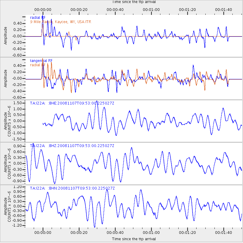
I22A 9 Mile Ranch, Kaycee, WY, USA - Earthquake Result Viewer
*The percent match for this event was below the threshold and hence no stack was calculated.
| Earthquake location: |
Vanuatu Islands |
| Earthquake latitude/longitude: |
-14.9/168.1 |
| Earthquake time(UTC): |
2008/11/07 (312) 09:40:00 GMT |
| Earthquake Depth: |
10 km |
| Earthquake Magnitude: |
5.5 MB, 4.9 MS, 5.5 MW |
| Earthquake Catalog/Contributor: |
WHDF/NEIC |
|
| Network: |
TA USArray Transportable Network (new EarthScope stations) |
| Station: |
I22A 9 Mile Ranch, Kaycee, WY, USA |
| Lat/Lon: |
43.89 N/106.48 W |
| Elevation: |
1430 m |
|
| Distance: |
96.9 deg |
| Az: |
46.547 deg |
| Baz: |
256.09 deg |
| Ray Param: |
$rayparam |
*The percent match for this event was below the threshold and hence was not used in the summary stack. |
|
| Radial Match: |
75.175514 % |
| Radial Bump: |
400 |
| Transverse Match: |
65.67735 % |
| Transverse Bump: |
400 |
| SOD ConfigId: |
2658 |
| Insert Time: |
2010-03-06 03:38:36.671 +0000 |
| GWidth: |
2.5 |
| Max Bumps: |
400 |
| Tol: |
0.001 |
|
Signal To Noise
| Channel | StoN | STA | LTA |
| TA:I22A: :BHZ:20081107T09:53:00.225027Z | 0.82307935 | 3.5112052E-7 | 4.2659377E-7 |
| TA:I22A: :BHN:20081107T09:53:00.225027Z | 1.1959981 | 4.6892478E-7 | 3.920782E-7 |
| TA:I22A: :BHE:20081107T09:53:00.225027Z | 2.682624 | 1.0625147E-6 | 3.960729E-7 |
| Arrivals |
| Ps | |
| PpPs | |
| PsPs/PpSs | |


