You are here: Home > Network List > CN - Canadian National Seismograph Network Stations List
> Station INK INUVIK, NT > Earthquake Result Viewer
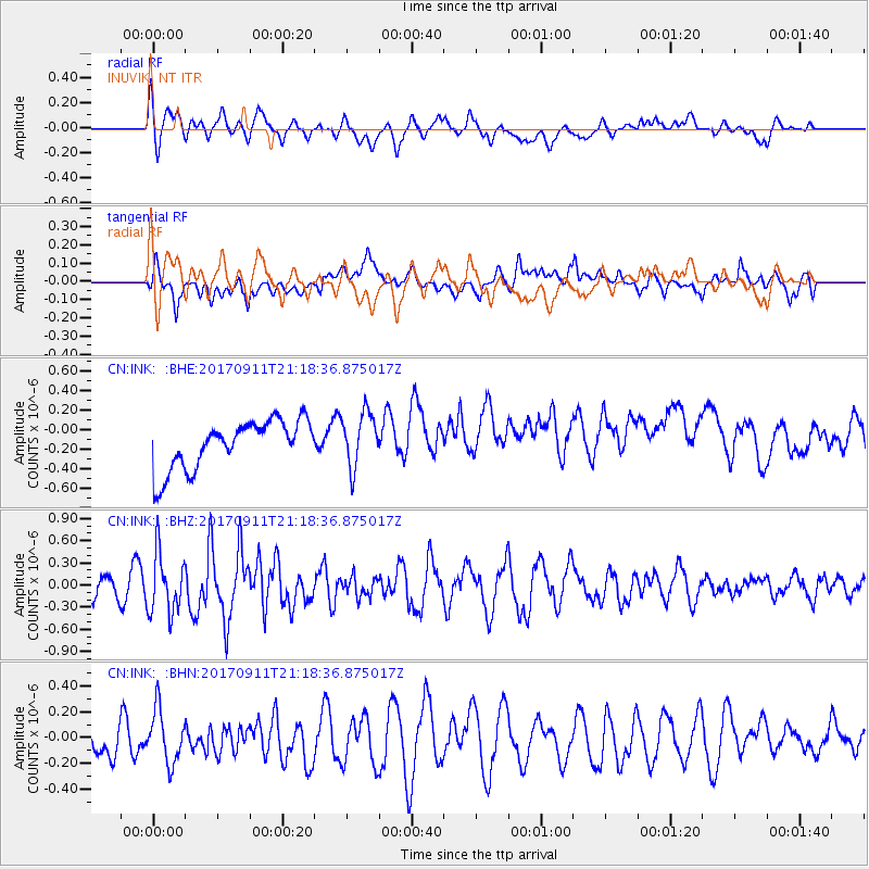
INK INUVIK, NT - Earthquake Result Viewer
*The percent match for this event was below the threshold and hence no stack was calculated.
| Earthquake location: |
Near Coast Of Chiapas, Mexico |
| Earthquake latitude/longitude: |
14.9/-93.9 |
| Earthquake time(UTC): |
2017/09/11 (254) 21:09:10 GMT |
| Earthquake Depth: |
27 km |
| Earthquake Magnitude: |
5.5 Mww |
| Earthquake Catalog/Contributor: |
NEIC PDE/us |
|
| Network: |
CN Canadian National Seismograph Network |
| Station: |
INK INUVIK, NT |
| Lat/Lon: |
68.31 N/133.53 W |
| Elevation: |
44 m |
|
| Distance: |
59.1 deg |
| Az: |
343.971 deg |
| Baz: |
134.097 deg |
| Ray Param: |
$rayparam |
*The percent match for this event was below the threshold and hence was not used in the summary stack. |
|
| Radial Match: |
49.20763 % |
| Radial Bump: |
400 |
| Transverse Match: |
45.843647 % |
| Transverse Bump: |
400 |
| SOD ConfigId: |
13570011 |
| Insert Time: |
2019-04-28 18:43:43.061 +0000 |
| GWidth: |
2.5 |
| Max Bumps: |
400 |
| Tol: |
0.001 |
|
Signal To Noise
| Channel | StoN | STA | LTA |
| CN:INK: :BHZ:20170911T21:18:36.875017Z | 2.0804875 | 4.0671586E-7 | 1.9549064E-7 |
| CN:INK: :BHN:20170911T21:18:36.875017Z | 1.5569046 | 2.0529636E-7 | 1.3186188E-7 |
| CN:INK: :BHE:20170911T21:18:36.875017Z | 1.1371236 | 2.7691456E-7 | 2.4352195E-7 |
| Arrivals |
| Ps | |
| PpPs | |
| PsPs/PpSs | |


