You are here: Home > Network List > TA - USArray Transportable Network (new EarthScope stations) Stations List
> Station I23A Meade Ranch, Gillette, WY, USA > Earthquake Result Viewer
I23A Meade Ranch, Gillette, WY, USA - Earthquake Result Viewer
| Earthquake location: |
Costa Rica |
| Earthquake latitude/longitude: |
10.2/-84.2 |
| Earthquake time(UTC): |
2009/01/08 (008) 19:21:35 GMT |
| Earthquake Depth: |
14 km |
| Earthquake Magnitude: |
5.7 MB, 6.0 MS, 6.1 MW, 6.1 MW |
| Earthquake Catalog/Contributor: |
WHDF/NEIC |
|
| Network: |
TA USArray Transportable Network (new EarthScope stations) |
| Station: |
I23A Meade Ranch, Gillette, WY, USA |
| Lat/Lon: |
43.96 N/105.46 W |
| Elevation: |
1462 m |
|
| Distance: |
38.4 deg |
| Az: |
335.052 deg |
| Baz: |
144.898 deg |
| Ray Param: |
0.07558117 |
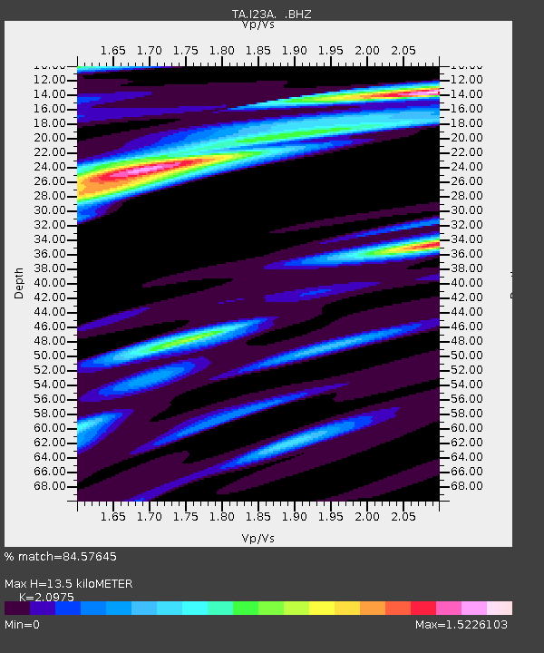
| Estimated Moho Depth: |
13.5 km |
| Estimated Crust Vp/Vs: |
2.10 |
| Assumed Crust Vp: |
6.159 km/s |
| Estimated Crust Vs: |
2.936 km/s |
| Estimated Crust Poisson's Ratio: |
0.35 |
|
| Radial Match: |
84.57645 % |
| Radial Bump: |
374 |
| Transverse Match: |
54.96602 % |
| Transverse Bump: |
400 |
| SOD ConfigId: |
2834 |
| Insert Time: |
2010-03-06 03:39:55.369 +0000 |
| GWidth: |
2.5 |
| Max Bumps: |
400 |
| Tol: |
0.001 |
|
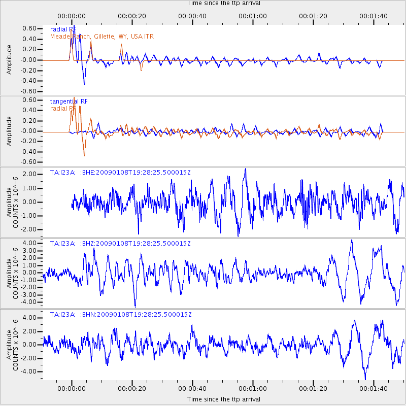
Signal To Noise
| Channel | StoN | STA | LTA |
| TA:I23A: :BHZ:20090108T19:28:25.500015Z | 3.009388 | 1.2297951E-6 | 4.0865288E-7 |
| TA:I23A: :BHN:20090108T19:28:25.500015Z | 1.3050172 | 8.594351E-7 | 6.5856227E-7 |
| TA:I23A: :BHE:20090108T19:28:25.500015Z | 1.3444356 | 7.0837365E-7 | 5.2689296E-7 |
| Arrivals |
| Ps | 2.5 SECOND |
| PpPs | 6.4 SECOND |
| PsPs/PpSs | 9.0 SECOND |


