You are here: Home > Network List > TA - USArray Transportable Network (new EarthScope stations) Stations List
> Station I23A Meade Ranch, Gillette, WY, USA > Earthquake Result Viewer
I23A Meade Ranch, Gillette, WY, USA - Earthquake Result Viewer
| Earthquake location: |
Norwegian Sea |
| Earthquake latitude/longitude: |
72.2/0.9 |
| Earthquake time(UTC): |
2009/08/20 (232) 06:35:04 GMT |
| Earthquake Depth: |
6.0 km |
| Earthquake Magnitude: |
5.9 MB, 5.7 MS, 6.0 MW, 6.0 MW |
| Earthquake Catalog/Contributor: |
WHDF/NEIC |
|
| Network: |
TA USArray Transportable Network (new EarthScope stations) |
| Station: |
I23A Meade Ranch, Gillette, WY, USA |
| Lat/Lon: |
43.96 N/105.46 W |
| Elevation: |
1462 m |
|
| Distance: |
53.5 deg |
| Az: |
300.425 deg |
| Baz: |
21.546 deg |
| Ray Param: |
0.06609981 |
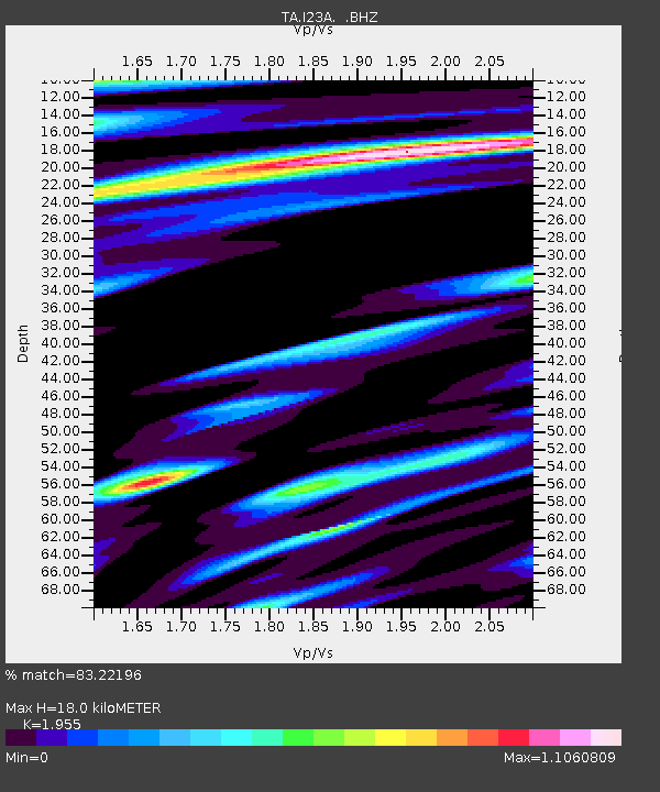
| Estimated Moho Depth: |
18.0 km |
| Estimated Crust Vp/Vs: |
1.96 |
| Assumed Crust Vp: |
6.159 km/s |
| Estimated Crust Vs: |
3.15 km/s |
| Estimated Crust Poisson's Ratio: |
0.32 |
|
| Radial Match: |
83.22196 % |
| Radial Bump: |
400 |
| Transverse Match: |
64.82915 % |
| Transverse Bump: |
400 |
| SOD ConfigId: |
2622 |
| Insert Time: |
2010-03-06 03:40:01.293 +0000 |
| GWidth: |
2.5 |
| Max Bumps: |
400 |
| Tol: |
0.001 |
|
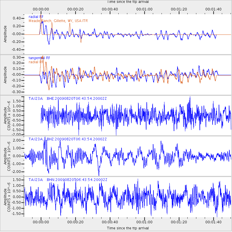
Signal To Noise
| Channel | StoN | STA | LTA |
| TA:I23A: :BHZ:20090820T06:43:54.20002Z | 3.4698389 | 1.2251048E-6 | 3.5307255E-7 |
| TA:I23A: :BHN:20090820T06:43:54.20002Z | 1.0673952 | 4.3015487E-7 | 4.0299497E-7 |
| TA:I23A: :BHE:20090820T06:43:54.20002Z | 0.7867341 | 4.4683313E-7 | 5.679595E-7 |
| Arrivals |
| Ps | 2.9 SECOND |
| PpPs | 8.3 SECOND |
| PsPs/PpSs | 11 SECOND |


