You are here: Home > Network List > TA - USArray Transportable Network (new EarthScope stations) Stations List
> Station I23A Meade Ranch, Gillette, WY, USA > Earthquake Result Viewer
I23A Meade Ranch, Gillette, WY, USA - Earthquake Result Viewer
| Earthquake location: |
Samoa Islands Region |
| Earthquake latitude/longitude: |
-15.2/-172.6 |
| Earthquake time(UTC): |
2009/08/30 (242) 14:51:32 GMT |
| Earthquake Depth: |
11 km |
| Earthquake Magnitude: |
6.4 MB, 6.3 MS, 6.6 MW, 6.6 MW |
| Earthquake Catalog/Contributor: |
WHDF/NEIC |
|
| Network: |
TA USArray Transportable Network (new EarthScope stations) |
| Station: |
I23A Meade Ranch, Gillette, WY, USA |
| Lat/Lon: |
43.96 N/105.46 W |
| Elevation: |
1462 m |
|
| Distance: |
84.8 deg |
| Az: |
41.914 deg |
| Baz: |
243.253 deg |
| Ray Param: |
0.0452229 |
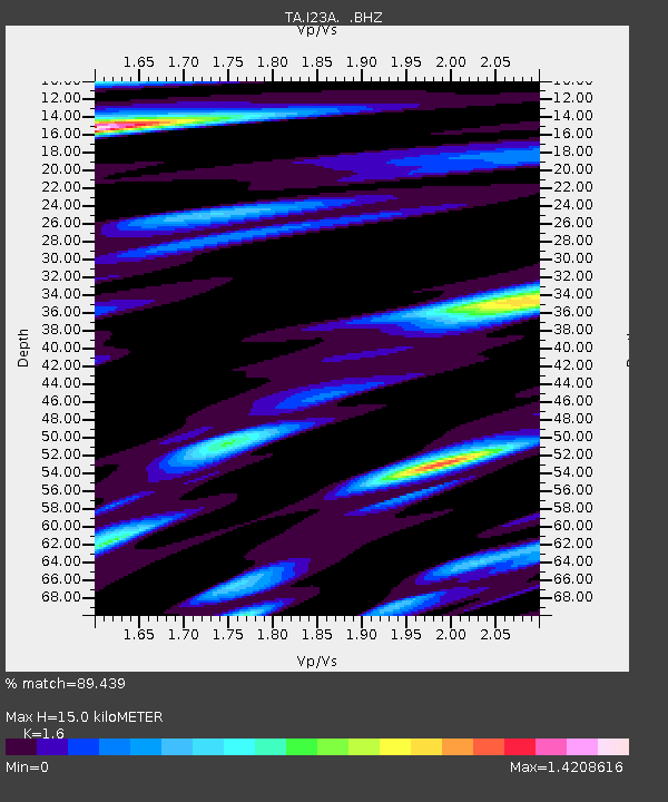
| Estimated Moho Depth: |
15.0 km |
| Estimated Crust Vp/Vs: |
1.60 |
| Assumed Crust Vp: |
6.159 km/s |
| Estimated Crust Vs: |
3.849 km/s |
| Estimated Crust Poisson's Ratio: |
0.18 |
|
| Radial Match: |
89.439 % |
| Radial Bump: |
400 |
| Transverse Match: |
82.48897 % |
| Transverse Bump: |
400 |
| SOD ConfigId: |
2622 |
| Insert Time: |
2010-03-06 03:40:04.400 +0000 |
| GWidth: |
2.5 |
| Max Bumps: |
400 |
| Tol: |
0.001 |
|
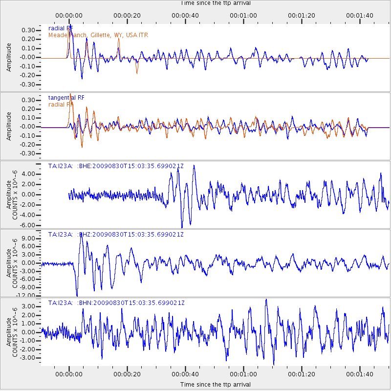
Signal To Noise
| Channel | StoN | STA | LTA |
| TA:I23A: :BHZ:20090830T15:03:35.699021Z | 16.210281 | 5.745413E-6 | 3.544302E-7 |
| TA:I23A: :BHN:20090830T15:03:35.699021Z | 2.0991428 | 7.8867225E-7 | 3.7571158E-7 |
| TA:I23A: :BHE:20090830T15:03:35.699021Z | 2.7328753 | 1.3894276E-6 | 5.084123E-7 |
| Arrivals |
| Ps | 1.5 SECOND |
| PpPs | 6.2 SECOND |
| PsPs/PpSs | 7.7 SECOND |


