You are here: Home > Network List > TA - USArray Transportable Network (new EarthScope stations) Stations List
> Station A36M Sachs Harbour, NT, CAN > Earthquake Result Viewer
A36M Sachs Harbour, NT, CAN - Earthquake Result Viewer
*The percent match for this event was below the threshold and hence no stack was calculated.
| Earthquake location: |
Near Coast Of Chiapas, Mexico |
| Earthquake latitude/longitude: |
14.9/-93.9 |
| Earthquake time(UTC): |
2017/09/11 (254) 21:09:10 GMT |
| Earthquake Depth: |
27 km |
| Earthquake Magnitude: |
5.5 Mww |
| Earthquake Catalog/Contributor: |
NEIC PDE/us |
|
| Network: |
TA USArray Transportable Network (new EarthScope stations) |
| Station: |
A36M Sachs Harbour, NT, CAN |
| Lat/Lon: |
71.99 N/125.25 W |
| Elevation: |
32 m |
|
| Distance: |
60.0 deg |
| Az: |
349.247 deg |
| Baz: |
144.556 deg |
| Ray Param: |
$rayparam |
*The percent match for this event was below the threshold and hence was not used in the summary stack. |
|
| Radial Match: |
55.420033 % |
| Radial Bump: |
400 |
| Transverse Match: |
51.20139 % |
| Transverse Bump: |
400 |
| SOD ConfigId: |
13570011 |
| Insert Time: |
2019-04-28 18:46:01.486 +0000 |
| GWidth: |
2.5 |
| Max Bumps: |
400 |
| Tol: |
0.001 |
|
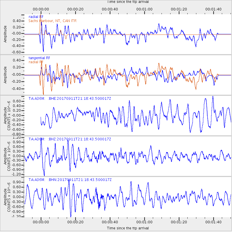
Signal To Noise
| Channel | StoN | STA | LTA |
| TA:A36M: :BHZ:20170911T21:18:43.500017Z | 4.2206936 | 6.1661433E-7 | 1.4609311E-7 |
| TA:A36M: :BHN:20170911T21:18:43.500017Z | 0.86041427 | 3.6936618E-7 | 4.2928875E-7 |
| TA:A36M: :BHE:20170911T21:18:43.500017Z | 0.94395626 | 1.9853512E-7 | 2.1032237E-7 |
| Arrivals |
| Ps | |
| PpPs | |
| PsPs/PpSs | |


