You are here: Home > Network List > TA - USArray Transportable Network (new EarthScope stations) Stations List
> Station C16K Lisburne Hills, AK, USA > Earthquake Result Viewer
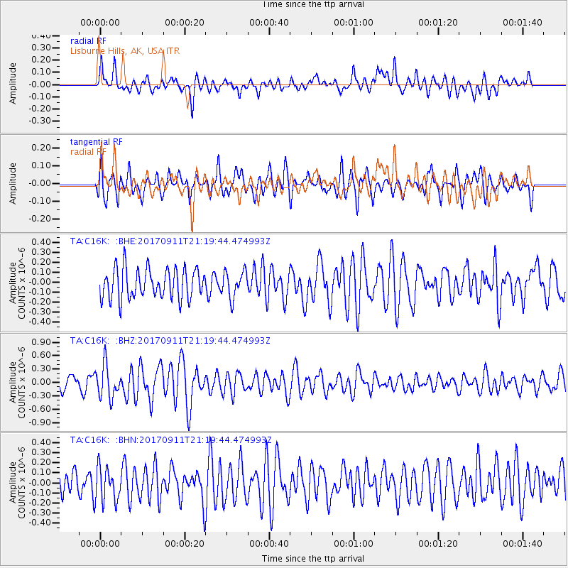
C16K Lisburne Hills, AK, USA - Earthquake Result Viewer
*The percent match for this event was below the threshold and hence no stack was calculated.
| Earthquake location: |
Near Coast Of Chiapas, Mexico |
| Earthquake latitude/longitude: |
14.9/-93.9 |
| Earthquake time(UTC): |
2017/09/11 (254) 21:09:10 GMT |
| Earthquake Depth: |
27 km |
| Earthquake Magnitude: |
5.5 Mww |
| Earthquake Catalog/Contributor: |
NEIC PDE/us |
|
| Network: |
TA USArray Transportable Network (new EarthScope stations) |
| Station: |
C16K Lisburne Hills, AK, USA |
| Lat/Lon: |
68.27 N/165.34 W |
| Elevation: |
102 m |
|
| Distance: |
69.4 deg |
| Az: |
337.858 deg |
| Baz: |
101.791 deg |
| Ray Param: |
$rayparam |
*The percent match for this event was below the threshold and hence was not used in the summary stack. |
|
| Radial Match: |
63.397026 % |
| Radial Bump: |
382 |
| Transverse Match: |
64.730034 % |
| Transverse Bump: |
400 |
| SOD ConfigId: |
13570011 |
| Insert Time: |
2019-04-28 18:46:01.900 +0000 |
| GWidth: |
2.5 |
| Max Bumps: |
400 |
| Tol: |
0.001 |
|
Signal To Noise
| Channel | StoN | STA | LTA |
| TA:C16K: :BHZ:20170911T21:19:44.474993Z | 2.4967005 | 3.7384945E-7 | 1.497374E-7 |
| TA:C16K: :BHN:20170911T21:19:44.474993Z | 1.0447363 | 1.6402501E-7 | 1.5700135E-7 |
| TA:C16K: :BHE:20170911T21:19:44.474993Z | 0.9038528 | 1.3484252E-7 | 1.4918636E-7 |
| Arrivals |
| Ps | |
| PpPs | |
| PsPs/PpSs | |


