You are here: Home > Network List > TA - USArray Transportable Network (new EarthScope stations) Stations List
> Station D23K Nanushuk River, AK USA > Earthquake Result Viewer
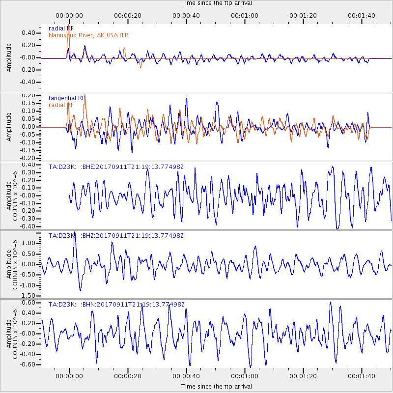
D23K Nanushuk River, AK USA - Earthquake Result Viewer
*The percent match for this event was below the threshold and hence no stack was calculated.
| Earthquake location: |
Near Coast Of Chiapas, Mexico |
| Earthquake latitude/longitude: |
14.9/-93.9 |
| Earthquake time(UTC): |
2017/09/11 (254) 21:09:10 GMT |
| Earthquake Depth: |
27 km |
| Earthquake Magnitude: |
5.5 Mww |
| Earthquake Catalog/Contributor: |
NEIC PDE/us |
|
| Network: |
TA USArray Transportable Network (new EarthScope stations) |
| Station: |
D23K Nanushuk River, AK USA |
| Lat/Lon: |
68.97 N/150.68 W |
| Elevation: |
406 m |
|
| Distance: |
64.6 deg |
| Az: |
340.474 deg |
| Baz: |
116.465 deg |
| Ray Param: |
$rayparam |
*The percent match for this event was below the threshold and hence was not used in the summary stack. |
|
| Radial Match: |
57.79184 % |
| Radial Bump: |
400 |
| Transverse Match: |
60.847473 % |
| Transverse Bump: |
400 |
| SOD ConfigId: |
13570011 |
| Insert Time: |
2019-04-28 18:46:11.645 +0000 |
| GWidth: |
2.5 |
| Max Bumps: |
400 |
| Tol: |
0.001 |
|
Signal To Noise
| Channel | StoN | STA | LTA |
| TA:D23K: :BHZ:20170911T21:19:13.77498Z | 4.2985578 | 7.2237435E-7 | 1.680504E-7 |
| TA:D23K: :BHN:20170911T21:19:13.77498Z | 0.80998564 | 1.2229354E-7 | 1.5098234E-7 |
| TA:D23K: :BHE:20170911T21:19:13.77498Z | 0.77227366 | 8.814838E-8 | 1.1414138E-7 |
| Arrivals |
| Ps | |
| PpPs | |
| PsPs/PpSs | |


