You are here: Home > Network List > TA - USArray Transportable Network (new EarthScope stations) Stations List
> Station I23A Meade Ranch, Gillette, WY, USA > Earthquake Result Viewer
I23A Meade Ranch, Gillette, WY, USA - Earthquake Result Viewer
| Earthquake location: |
Honduras |
| Earthquake latitude/longitude: |
15.8/-86.9 |
| Earthquake time(UTC): |
2009/06/08 (159) 05:13:14 GMT |
| Earthquake Depth: |
10 km |
| Earthquake Magnitude: |
5.5 MB, 4.9 MS, 5.4 MW, 5.4 MW |
| Earthquake Catalog/Contributor: |
WHDF/NEIC |
|
| Network: |
TA USArray Transportable Network (new EarthScope stations) |
| Station: |
I23A Meade Ranch, Gillette, WY, USA |
| Lat/Lon: |
43.96 N/105.46 W |
| Elevation: |
1462 m |
|
| Distance: |
32.2 deg |
| Az: |
334.407 deg |
| Baz: |
144.839 deg |
| Ray Param: |
0.078744724 |
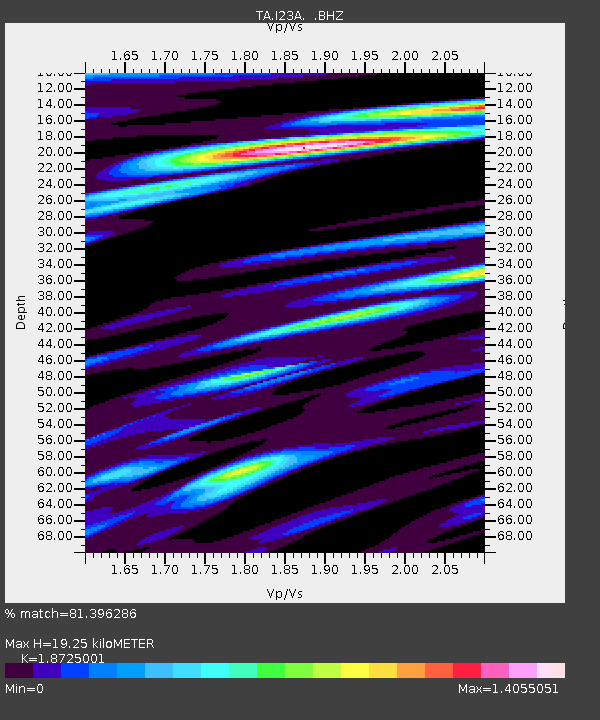
| Estimated Moho Depth: |
19.25 km |
| Estimated Crust Vp/Vs: |
1.87 |
| Assumed Crust Vp: |
6.159 km/s |
| Estimated Crust Vs: |
3.289 km/s |
| Estimated Crust Poisson's Ratio: |
0.30 |
|
| Radial Match: |
81.396286 % |
| Radial Bump: |
400 |
| Transverse Match: |
57.862404 % |
| Transverse Bump: |
400 |
| SOD ConfigId: |
2648 |
| Insert Time: |
2010-03-06 03:40:18.157 +0000 |
| GWidth: |
2.5 |
| Max Bumps: |
400 |
| Tol: |
0.001 |
|
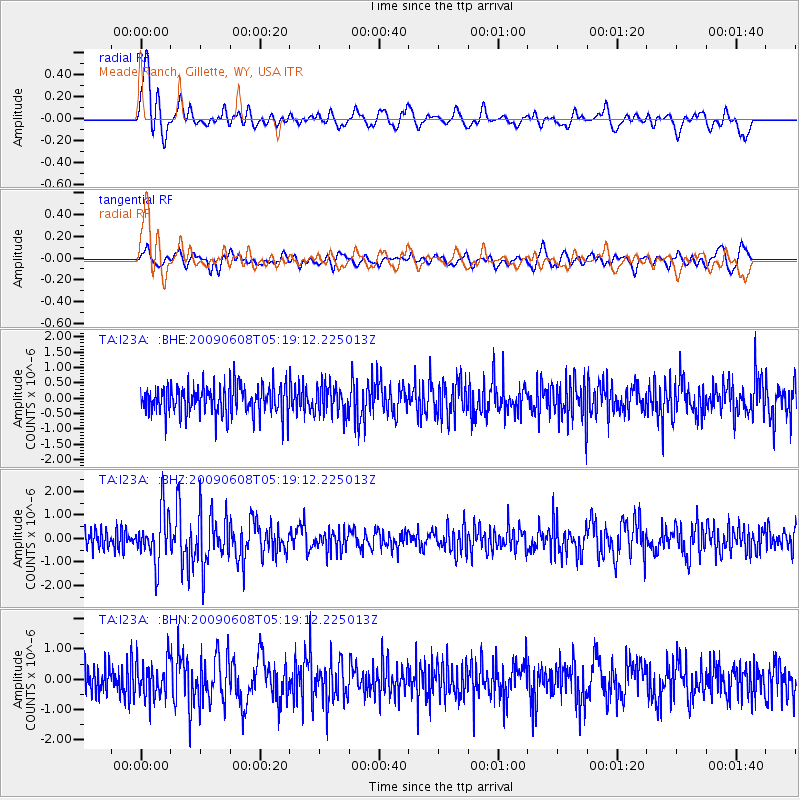
Signal To Noise
| Channel | StoN | STA | LTA |
| TA:I23A: :BHZ:20090608T05:19:12.225013Z | 2.6184254 | 1.0755166E-6 | 4.1074935E-7 |
| TA:I23A: :BHN:20090608T05:19:12.225013Z | 1.2330421 | 5.99456E-7 | 4.8616016E-7 |
| TA:I23A: :BHE:20090608T05:19:12.225013Z | 0.9807396 | 4.772274E-7 | 4.865995E-7 |
| Arrivals |
| Ps | 2.9 SECOND |
| PpPs | 8.4 SECOND |
| PsPs/PpSs | 11 SECOND |


