You are here: Home > Network List > TA - USArray Transportable Network (new EarthScope stations) Stations List
> Station I23A Meade Ranch, Gillette, WY, USA > Earthquake Result Viewer
I23A Meade Ranch, Gillette, WY, USA - Earthquake Result Viewer
| Earthquake location: |
Panama |
| Earthquake latitude/longitude: |
9.6/-79.0 |
| Earthquake time(UTC): |
2009/07/04 (185) 06:49:35 GMT |
| Earthquake Depth: |
38 km |
| Earthquake Magnitude: |
6.0 MB, 5.5 MS, 6.0 MW, 6.0 MW |
| Earthquake Catalog/Contributor: |
WHDF/NEIC |
|
| Network: |
TA USArray Transportable Network (new EarthScope stations) |
| Station: |
I23A Meade Ranch, Gillette, WY, USA |
| Lat/Lon: |
43.96 N/105.46 W |
| Elevation: |
1462 m |
|
| Distance: |
41.2 deg |
| Az: |
330.747 deg |
| Baz: |
138.137 deg |
| Ray Param: |
0.073825255 |
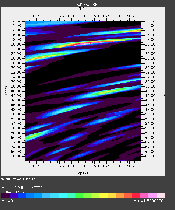
| Estimated Moho Depth: |
19.5 km |
| Estimated Crust Vp/Vs: |
1.88 |
| Assumed Crust Vp: |
6.159 km/s |
| Estimated Crust Vs: |
3.28 km/s |
| Estimated Crust Poisson's Ratio: |
0.30 |
|
| Radial Match: |
91.66873 % |
| Radial Bump: |
400 |
| Transverse Match: |
85.40503 % |
| Transverse Bump: |
400 |
| SOD ConfigId: |
2648 |
| Insert Time: |
2010-03-06 03:40:22.687 +0000 |
| GWidth: |
2.5 |
| Max Bumps: |
400 |
| Tol: |
0.001 |
|
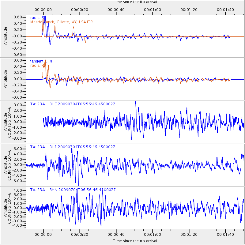
Signal To Noise
| Channel | StoN | STA | LTA |
| TA:I23A: :BHZ:20090704T06:56:46.450002Z | 4.9604616 | 1.8725417E-6 | 3.7749345E-7 |
| TA:I23A: :BHN:20090704T06:56:46.450002Z | 1.8892832 | 7.757668E-7 | 4.1061438E-7 |
| TA:I23A: :BHE:20090704T06:56:46.450002Z | 1.6019248 | 7.103823E-7 | 4.434555E-7 |
| Arrivals |
| Ps | 2.9 SECOND |
| PpPs | 8.6 SECOND |
| PsPs/PpSs | 12 SECOND |


