You are here: Home > Network List > TA - USArray Transportable Network (new EarthScope stations) Stations List
> Station I23A Meade Ranch, Gillette, WY, USA > Earthquake Result Viewer
I23A Meade Ranch, Gillette, WY, USA - Earthquake Result Viewer
| Earthquake location: |
Baffin Bay |
| Earthquake latitude/longitude: |
75.4/-72.5 |
| Earthquake time(UTC): |
2009/07/07 (188) 19:11:46 GMT |
| Earthquake Depth: |
19 km |
| Earthquake Magnitude: |
5.9 MB, 5.7 MS, 6.1 MW, 6.0 MW |
| Earthquake Catalog/Contributor: |
WHDF/NEIC |
|
| Network: |
TA USArray Transportable Network (new EarthScope stations) |
| Station: |
I23A Meade Ranch, Gillette, WY, USA |
| Lat/Lon: |
43.96 N/105.46 W |
| Elevation: |
1462 m |
|
| Distance: |
34.6 deg |
| Az: |
223.846 deg |
| Baz: |
14.13 deg |
| Ray Param: |
0.07763378 |
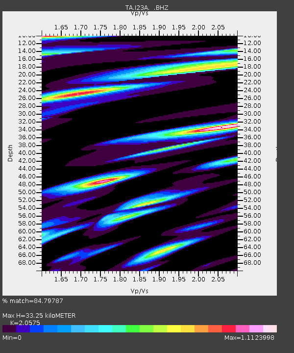
| Estimated Moho Depth: |
33.25 km |
| Estimated Crust Vp/Vs: |
2.06 |
| Assumed Crust Vp: |
6.159 km/s |
| Estimated Crust Vs: |
2.993 km/s |
| Estimated Crust Poisson's Ratio: |
0.35 |
|
| Radial Match: |
84.79787 % |
| Radial Bump: |
400 |
| Transverse Match: |
70.92816 % |
| Transverse Bump: |
400 |
| SOD ConfigId: |
2648 |
| Insert Time: |
2010-03-06 03:40:27.317 +0000 |
| GWidth: |
2.5 |
| Max Bumps: |
400 |
| Tol: |
0.001 |
|
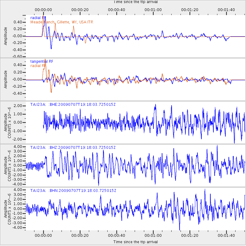
Signal To Noise
| Channel | StoN | STA | LTA |
| TA:I23A: :BHZ:20090707T19:18:03.725015Z | 2.8579502 | 1.4797298E-6 | 5.177591E-7 |
| TA:I23A: :BHN:20090707T19:18:03.725015Z | 1.769851 | 8.624304E-7 | 4.8728987E-7 |
| TA:I23A: :BHE:20090707T19:18:03.725015Z | 0.7299994 | 3.874564E-7 | 5.3076263E-7 |
| Arrivals |
| Ps | 6.1 SECOND |
| PpPs | 16 SECOND |
| PsPs/PpSs | 22 SECOND |


