You are here: Home > Network List > TA - USArray Transportable Network (new EarthScope stations) Stations List
> Station I23A Meade Ranch, Gillette, WY, USA > Earthquake Result Viewer
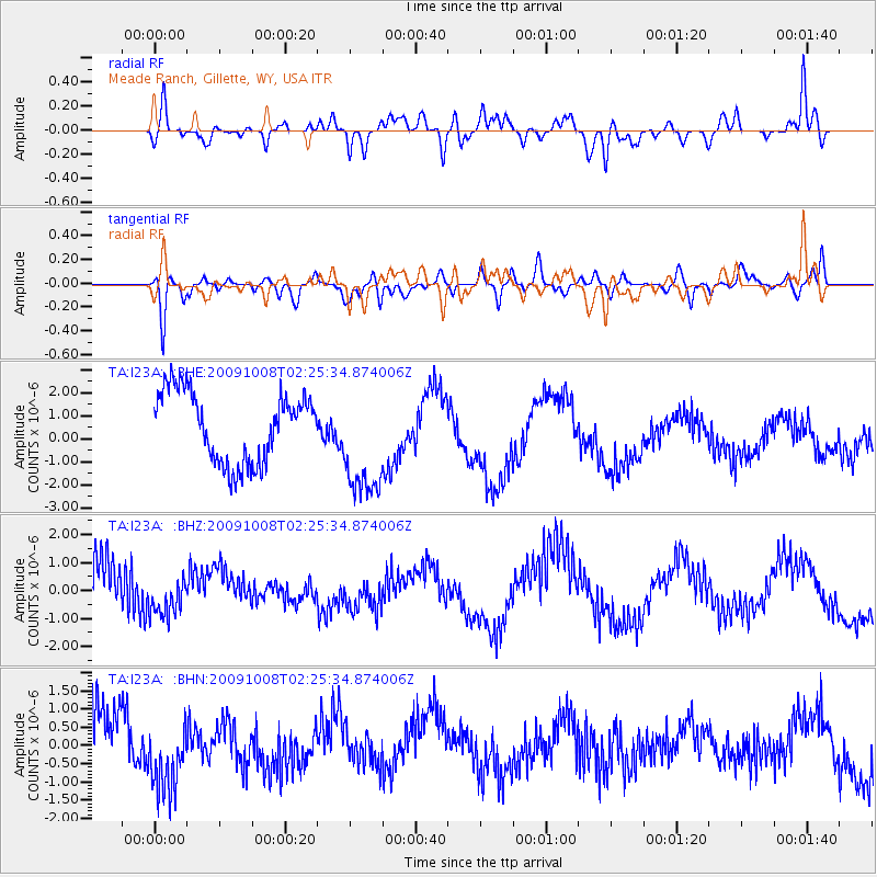
I23A Meade Ranch, Gillette, WY, USA - Earthquake Result Viewer
*The percent match for this event was below the threshold and hence no stack was calculated.
| Earthquake location: |
Santa Cruz Islands |
| Earthquake latitude/longitude: |
-11.7/166.2 |
| Earthquake time(UTC): |
2009/10/08 (281) 02:12:39 GMT |
| Earthquake Depth: |
35 km |
| Earthquake Magnitude: |
5.8 MB, 6.6 MW |
| Earthquake Catalog/Contributor: |
WHDF/NEIC |
|
| Network: |
TA USArray Transportable Network (new EarthScope stations) |
| Station: |
I23A Meade Ranch, Gillette, WY, USA |
| Lat/Lon: |
43.96 N/105.46 W |
| Elevation: |
1462 m |
|
| Distance: |
96.8 deg |
| Az: |
46.634 deg |
| Baz: |
260.469 deg |
| Ray Param: |
$rayparam |
*The percent match for this event was below the threshold and hence was not used in the summary stack. |
|
| Radial Match: |
39.73826 % |
| Radial Bump: |
343 |
| Transverse Match: |
72.45825 % |
| Transverse Bump: |
400 |
| SOD ConfigId: |
2622 |
| Insert Time: |
2010-03-06 03:40:49.210 +0000 |
| GWidth: |
2.5 |
| Max Bumps: |
400 |
| Tol: |
0.001 |
|
Signal To Noise
| Channel | StoN | STA | LTA |
| TA:I23A: :BHZ:20091008T02:25:34.874006Z | 0.8586855 | 7.473902E-7 | 8.703887E-7 |
| TA:I23A: :BHN:20091008T02:25:34.874006Z | 1.3070127 | 1.1176908E-6 | 8.5514915E-7 |
| TA:I23A: :BHE:20091008T02:25:34.874006Z | 1.6417783 | 2.4715264E-6 | 1.5053959E-6 |
| Arrivals |
| Ps | |
| PpPs | |
| PsPs/PpSs | |


