You are here: Home > Network List > AV - Alaska Volcano Observatory Stations List
> Station MAPS Pakushin Southeast, Makushin Volcano, Alaska > Earthquake Result Viewer
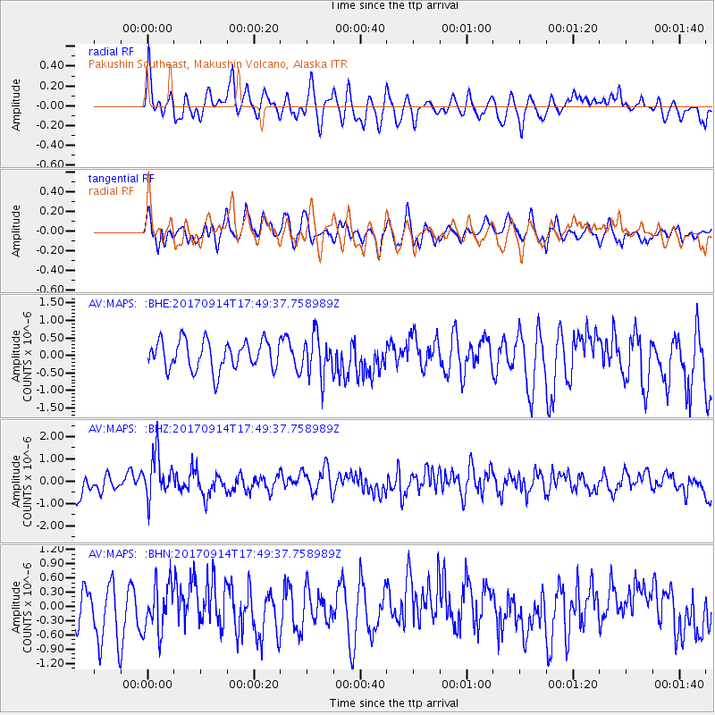
MAPS Pakushin Southeast, Makushin Volcano, Alaska - Earthquake Result Viewer
*The percent match for this event was below the threshold and hence no stack was calculated.
| Earthquake location: |
Mariana Islands |
| Earthquake latitude/longitude: |
18.7/145.7 |
| Earthquake time(UTC): |
2017/09/14 (257) 17:41:28 GMT |
| Earthquake Depth: |
173 km |
| Earthquake Magnitude: |
5.8 mww |
| Earthquake Catalog/Contributor: |
NEIC PDE/us |
|
| Network: |
AV Alaska Volcano Observatory |
| Station: |
MAPS Pakushin Southeast, Makushin Volcano, Alaska |
| Lat/Lon: |
53.81 N/166.94 W |
| Elevation: |
333 m |
|
| Distance: |
50.4 deg |
| Az: |
34.461 deg |
| Baz: |
244.755 deg |
| Ray Param: |
$rayparam |
*The percent match for this event was below the threshold and hence was not used in the summary stack. |
|
| Radial Match: |
66.38 % |
| Radial Bump: |
400 |
| Transverse Match: |
54.827026 % |
| Transverse Bump: |
400 |
| SOD ConfigId: |
13570011 |
| Insert Time: |
2019-04-28 18:50:52.677 +0000 |
| GWidth: |
2.5 |
| Max Bumps: |
400 |
| Tol: |
0.001 |
|
Signal To Noise
| Channel | StoN | STA | LTA |
| AV:MAPS: :BHZ:20170914T17:49:37.758989Z | 2.3513794 | 9.860969E-7 | 4.1936954E-7 |
| AV:MAPS: :BHN:20170914T17:49:37.758989Z | 1.010405 | 4.9421794E-7 | 4.891286E-7 |
| AV:MAPS: :BHE:20170914T17:49:37.758989Z | 1.4326394 | 5.917835E-7 | 4.130722E-7 |
| Arrivals |
| Ps | |
| PpPs | |
| PsPs/PpSs | |


