You are here: Home > Network List > TA - USArray Transportable Network (new EarthScope stations) Stations List
> Station D25K Kavik River, AK, USA > Earthquake Result Viewer
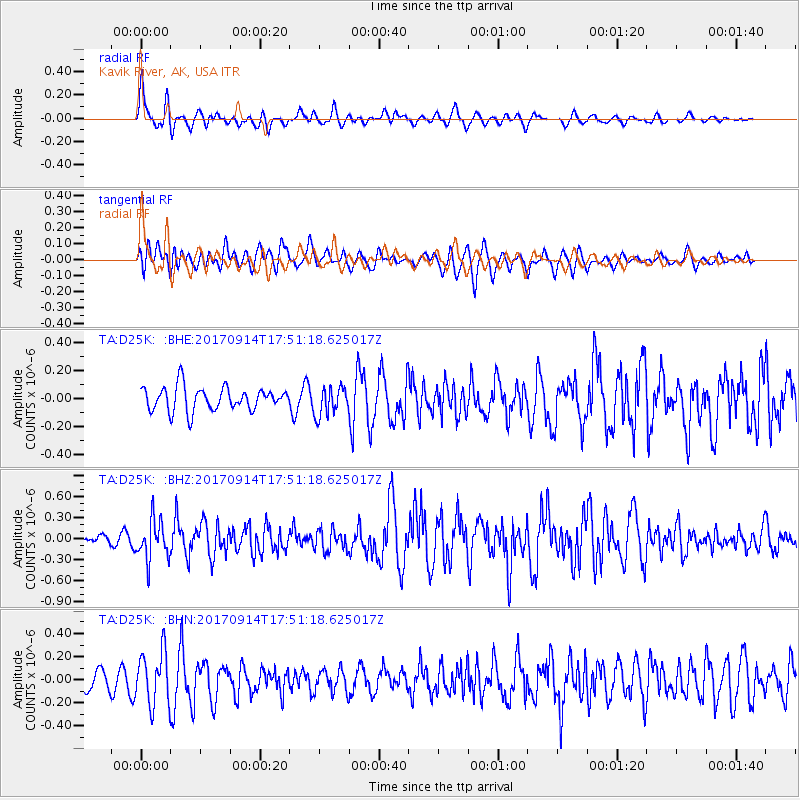
D25K Kavik River, AK, USA - Earthquake Result Viewer
*The percent match for this event was below the threshold and hence no stack was calculated.
| Earthquake location: |
Mariana Islands |
| Earthquake latitude/longitude: |
18.7/145.7 |
| Earthquake time(UTC): |
2017/09/14 (257) 17:41:28 GMT |
| Earthquake Depth: |
173 km |
| Earthquake Magnitude: |
5.8 mww |
| Earthquake Catalog/Contributor: |
NEIC PDE/us |
|
| Network: |
TA USArray Transportable Network (new EarthScope stations) |
| Station: |
D25K Kavik River, AK, USA |
| Lat/Lon: |
69.32 N/146.38 W |
| Elevation: |
770 m |
|
| Distance: |
64.9 deg |
| Az: |
21.309 deg |
| Baz: |
255.908 deg |
| Ray Param: |
$rayparam |
*The percent match for this event was below the threshold and hence was not used in the summary stack. |
|
| Radial Match: |
69.42772 % |
| Radial Bump: |
400 |
| Transverse Match: |
54.097027 % |
| Transverse Bump: |
400 |
| SOD ConfigId: |
13570011 |
| Insert Time: |
2019-04-28 18:54:59.649 +0000 |
| GWidth: |
2.5 |
| Max Bumps: |
400 |
| Tol: |
0.001 |
|
Signal To Noise
| Channel | StoN | STA | LTA |
| TA:D25K: :BHZ:20170914T17:51:18.625017Z | 2.5393867 | 2.8216317E-7 | 1.1111469E-7 |
| TA:D25K: :BHN:20170914T17:51:18.625017Z | 1.7817367 | 2.2797084E-7 | 1.2794868E-7 |
| TA:D25K: :BHE:20170914T17:51:18.625017Z | 1.2160269 | 1.0235013E-7 | 8.416765E-8 |
| Arrivals |
| Ps | |
| PpPs | |
| PsPs/PpSs | |


