You are here: Home > Network List > TJ - Tajikistan National Seismic Network Stations List
> Station CHRDR Chorukh Dayron, Tajikistan > Earthquake Result Viewer
CHRDR Chorukh Dayron, Tajikistan - Earthquake Result Viewer
| Earthquake location: |
Mariana Islands |
| Earthquake latitude/longitude: |
18.7/145.7 |
| Earthquake time(UTC): |
2017/09/14 (257) 17:41:28 GMT |
| Earthquake Depth: |
173 km |
| Earthquake Magnitude: |
5.8 mww |
| Earthquake Catalog/Contributor: |
NEIC PDE/us |
|
| Network: |
TJ Tajikistan National Seismic Network |
| Station: |
CHRDR Chorukh Dayron, Tajikistan |
| Lat/Lon: |
40.39 N/69.67 E |
| Elevation: |
580 m |
|
| Distance: |
67.7 deg |
| Az: |
306.737 deg |
| Baz: |
84.065 deg |
| Ray Param: |
0.05631369 |
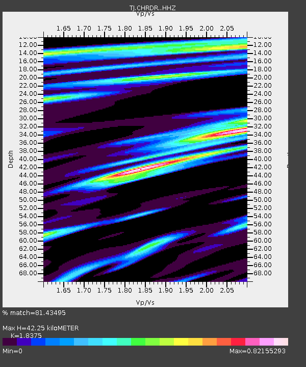
| Estimated Moho Depth: |
42.25 km |
| Estimated Crust Vp/Vs: |
1.84 |
| Assumed Crust Vp: |
6.316 km/s |
| Estimated Crust Vs: |
3.437 km/s |
| Estimated Crust Poisson's Ratio: |
0.29 |
|
| Radial Match: |
81.43495 % |
| Radial Bump: |
400 |
| Transverse Match: |
75.279495 % |
| Transverse Bump: |
400 |
| SOD ConfigId: |
13570011 |
| Insert Time: |
2019-04-28 18:56:42.531 +0000 |
| GWidth: |
2.5 |
| Max Bumps: |
400 |
| Tol: |
0.001 |
|

Signal To Noise
| Channel | StoN | STA | LTA |
| TJ:CHRDR: :HHZ:20170914T17:51:36.219988Z | 7.031137 | 5.5433816E-7 | 7.884047E-8 |
| TJ:CHRDR: :HHN:20170914T17:51:36.219988Z | 1.2611253 | 9.799708E-8 | 7.770606E-8 |
| TJ:CHRDR: :HHE:20170914T17:51:36.219988Z | 3.416095 | 2.2951464E-7 | 6.7186264E-8 |
| Arrivals |
| Ps | 5.8 SECOND |
| PpPs | 18 SECOND |
| PsPs/PpSs | 24 SECOND |


