You are here: Home > Network List > UW - Pacific Northwest Regional Seismic Network Stations List
> Station YACT Amboy, WA, USA > Earthquake Result Viewer
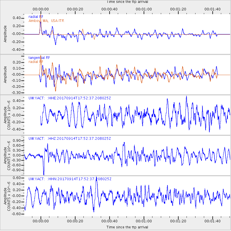
YACT Amboy, WA, USA - Earthquake Result Viewer
*The percent match for this event was below the threshold and hence no stack was calculated.
| Earthquake location: |
Mariana Islands |
| Earthquake latitude/longitude: |
18.7/145.7 |
| Earthquake time(UTC): |
2017/09/14 (257) 17:41:28 GMT |
| Earthquake Depth: |
173 km |
| Earthquake Magnitude: |
5.8 mww |
| Earthquake Catalog/Contributor: |
NEIC PDE/us |
|
| Network: |
UW Pacific Northwest Regional Seismic Network |
| Station: |
YACT Amboy, WA, USA |
| Lat/Lon: |
45.93 N/122.42 W |
| Elevation: |
211 m |
|
| Distance: |
78.1 deg |
| Az: |
45.473 deg |
| Baz: |
284.439 deg |
| Ray Param: |
$rayparam |
*The percent match for this event was below the threshold and hence was not used in the summary stack. |
|
| Radial Match: |
56.372894 % |
| Radial Bump: |
400 |
| Transverse Match: |
54.95577 % |
| Transverse Bump: |
400 |
| SOD ConfigId: |
13570011 |
| Insert Time: |
2019-04-28 18:57:27.719 +0000 |
| GWidth: |
2.5 |
| Max Bumps: |
400 |
| Tol: |
0.001 |
|
Signal To Noise
| Channel | StoN | STA | LTA |
| UW:YACT: :HHZ:20170914T17:52:37.208025Z | 2.7480547 | 4.320492E-7 | 1.5722001E-7 |
| UW:YACT: :HHN:20170914T17:52:37.208025Z | 0.8524188 | 1.6146959E-7 | 1.894252E-7 |
| UW:YACT: :HHE:20170914T17:52:37.208025Z | 0.6835298 | 1.2746017E-7 | 1.8647347E-7 |
| Arrivals |
| Ps | |
| PpPs | |
| PsPs/PpSs | |


